1). “Central Florida braces for life-threatening impacts from Hurricane Milton landfall as a major hurricane”, Oct 6, 2024 updated Oct 9, 2024, Bill Deger & Alex Sosnowski, AccuWeather senior meteorologist, AccuWeather, at < https://www.accuweather.com/
2). “Expert: Climate change, aging infrastructure, human decisions feed into disasters like Hurricane Helene”, Sep 30, 2024, Manoochehr Shirzaei, Virginia Tech News, at < https://news.vt.edu/articles/
3). “Climate change key driver of catastrophic impacts of Hurricane Helene that devastated both coastal and inland communities”, Oct 9, 2024, Anon, Climate Attribution, at < https://www.
4). “Hurricanes like Helene twice as likely to happen due to global heating, data finds: Analysis shows Gulf’s heat that worsened Helene 200-500 times more likely because of human-caused global heating”, Oct 9, 2024, Oliver Milman & Jonathan Watts, The Guardian, at < https://www.theguardian.com/
5). “Hurricane Milton: Vance Claims 'Even Obama' Was Better Than Harris in a Crisis”, Oct 09, 2024, Hugh Cameron, Newsweek, at < https://www.newsweek.com/
6). “Biden-Harris Mismanaged Hurricane Helene: A White House that tried to shift FEMA’s priorities left the citizens of North Carolina suffering for days”, Oct 8, 2024, J. D. Vance, Wall Street Journal, at < https://www.wsj.com/opinion/
~~ recommended by dmorista ~~
Introduction by dmorista: After a quiet early part of the Hurricane Season the second of two giant hurricanes is about to hit Florida. Item 1)., “Central Florida braces ….”, Item 2)., “Expert: Climate change, aging infrastructure, ….”, Item 3). “Climate change key driver ….”, Item 4)., “Hurricanes like Helene ….”; all discuss the effects of Climate Change (primarily the effects of Global Warming) on the increasing severity and frequency of tropical storms and hurricanes. Item 2 mentions the increasing problem of antiquated and inadequate infrastructure that cannot begin to cope with the problems posed by the increasingly difficult conditions when stronger storms pour much larger amounts of rain, or push higher storm surges onto the shoreline and into developed areas. Item 1 provides a number of fine graphics and maps that illustrate a variety of disastrous effects that the oncoming Hurricane Milton will wreak on Florida.
Items 5., “Hurricane Milton: Vance Claims ….”, Item 6., “Biden-Harris Mismanaged ....", look at some of the distortions and lying statements made by Trump and Vance. Item 6 is actually a column written by Vance himself in which he expounds on his endless blaming Kamala Harris (and Biden) for every problem the country has.
Large areas of the S.E. will still be in the relatively early stages of recovery when the election day arrives. Many will probably still be without electricity, telephone, or internet services. How will this affect the election, particularly in the swing states of North Carolina and Georgia. Certainly turnout will be significantly reduced in the worst affected areas.
xxxxxxxxxxxxxxxxxxxxxxx
Central Florida braces for life-threatening impacts from Major Hurricane Milton at landfall
Milton has been upgraded to a 5 on AccuWeather’s RealImpact Scale for Hurricanes as the “once-in-a-lifetime” storm poses a significant threat to Florida, including record-breaking storm surge.
By Alex Sosnowski, AccuWeather senior meteorologist & Bill Deger, AccuWeather senior meteorologist
Published Oct 6, 2024 10:57 AM EDT | Updated Oct 9, 2024 10:00 AM EDT
Key takeaways:
•Milton is poised to make landfall within a dozen miles of the islands at the mouth of Tampa Bay along the west-central coast of Florida late Wednesday evening as a major hurricane.
•A life-threatening and highly destructive storm surge will occur near and just south of where the eye moves ashore.
•Flooding rainfall and damaging wind gusts will occur in many areas of the Florida Peninsula with hurricane conditions throughout the I-4 corridor.

Hurricane Milton will remain a powerful, potentially deadly and destructive force as it roars ashore in the Florida Peninsula along the central Gulf coast around 11 p.m. EDT Wednesday, AccuWeather meteorologists continue to warn.
Milton intensified rapidly and nearly tripled in strength in less than 36 hours from Sunday to Monday, eventually becoming a Category 5 with winds of 180 mph while spinning off Mexico's Yucatan Peninsula. Category 5 is the highest level on the Saffir-Simpson Hurricane Wind Scale.

"Some changes within the eye caused the storm's peak wind intensity to ease on Monday night, but as anticipated, some regaining of strength occurred on Tuesday afternoon," AccuWeather Lead Hurricane Expert Alex DaSilva said. Milton regained Category 5 intensity with maximum sustained winds of 165 mph.
"On Wednesday, as Milton encounters some wind shear and another eyewall replacement cycle, it is forecast to expand in size and lose some wind intensity," DaSilva added, Milton will make landfall as a formidable Category 4 hurricane on the Saffir-Simpson scale late Wednesday evening," DaSilva added.
However, hurricane experts continue to maintain that Milton will strike with the impacts of a 5 on AccuWeather's RealImpact™ Scale for Hurricanes, which takes into account storm surge, flooding rainfall, population affected and economic impacts above and beyond the Saffir-Simpson scale, which takes into account only maximum sustained winds.

Only if Milton's peak winds ease more than anticipated with a less-defined eye or should Milton track into a low population zone farther to the south along the Florida coast would the RealImpact™ scale be less than a 5.
The RealImpact™ of 5 is highly scrutinized by AccuWeather meteorologists and has only been designated for storms such as Ian, Dorian, Harvey, Sandy, Katrina and Andrew, so this truly would be a once-in-a-lifetime event for the millions of people in the Tampa-St. Petersburg-Sarasota area.
Deadly, dangerous and historic storm surge anticipated
By far, the most dangerous aspect of Milton as it approaches the Gulf coast of the Florida Peninsula will be storm surge. Because of the near-perpendicular angle at which Milton will roar ashore, the storm surge near and south of where the eye makes landfall will be maximized along the barrier islands and funneled into the many inland bays in the region.
“This is an unusual and extremely concerning forecast track for a hurricane approaching the west-central Florida coast and the Tampa Bay area,” warned AccuWeather Chief Meteorologist Jonathan Porter, "For many, Milton may be a once-in-a-lifetime hurricane in terms of severity."

A record storm surge can occur near and just to the south of where the eye moves ashore. At this time, a storm surge of 15-20 feet is forecast for part of Tampa Bay, as well as the Sarasota and Venice, Florida areas. The storm surge will drop off significantly north of where the eye rolls in but can be delayed and build after the storm moves inland.
Significant, dangerous and damaging water rise will occur well to the south of where the eye rolls in with a storm surge of 10-15 feet from south of Venice to Cape Coral and Fort Myers, Florida, and 6-10 feet possible in Naples and Marco Island, Florida. However, even at these levels, great risk to lives and devastation can occur. North of the eyewall, the storm surge will drop off significantly, but powerful winds will lead to major damage.
Powerful hurricanes such as Milton tend to wobble as they move along. Any southward shift in the eye could take some of the edge off the level of storm surge north of the center as winds try to push water away. Correspondingly, any northward shift in the track could bring the strongest onshore winds and highest surge into some communities where less extreme levels were originally forecast. In short, every shift in track by a mile or two can make a huge difference in the magnitude of the storm surge due to the intense counterclockwise circulation around the eye.
"Near and just south of where the eye rolls in around 11 p.m. EDT Wednesday, some barrier islands and coastal mainland communities may experience extensive damage and may be altered permanently," AccuWeather Chief On-Air Meteorologist Bernie Rayno said. "That's how bad Milton can be."

AccuWeather meteorologists and government officials warn that because of the expected level of inundation, those in an evacuation zone who do not leave will be putting their lives at serious risk. The storm surge anticipated in some communities will reach the level of one—and two-story buildings and can reach that level with tremendous force in a matter of a few minutes.
Large floating objects along the coast will act as battering rams in storm surge areas.
Shifting winds from the southwest to the west then the northwest may keep water levels elevated even many hours after Milton moves inland.
Destructive, power-robbing winds coming right through I-4 corridor
Winds reaching the strength of a Category 4 hurricane (130-156 mph) with gusts of 140-160 mph will cause extensive damage and destruction to older homes and buildings. Loose objects and piles of debris will become projectiles.

As Milton approaches the Florida coast Wednesday and makes landfall late Wednesday night, it will grow in size, and its tropical-storm- and hurricane-force winds will spread out.
"We expect hurricane conditions throughout the Interstate 4 corridor which will be close to the track of Milton as it moves inland," Porter warned. Major metro areas that can expect the impacts of a hurricane include Orlando, Winter Haven and Daytona Beach.
Widespread tree and power line damage will occur, with millions likely to be without power. Some of the power outages may last many days to weeks in the hardest-hit areas, especially since some of the distant utility crews that would typically assist for Milton are still working on restoring power in the wake of Helene over northern Florida, Georgia and the Carolinas.

Rain to swamp streets, trigger rises on rivers and lakes
Another damaging and disruptive aspect of Milton will be tremendous rainfall. While the forward speed of the hurricane will limit the duration of the heaviest downpours, rainfall rates of 3-5 inches per hour can occur, which are more than enough to overwhelm storm drains and flood low-lying areas despite Florida's sandy soil.
AccuWeather meteorologists expect a broad area where 8-12 inches of rain will pour down over the central and northern parts of the Florida Peninsula, but within this zone, a narrow corridor of 12-18 inches of rain may occur with an AccuWeather Local StormMax™ rainfall of 30 inches.

This magnitude of rain will raise creeks, lakes, and rivers in the region. Many of the large rivers are considered to be slow-flowing and near sea level, so it could take many days and even weeks for waters to recede completely.
A storm surge near the coast and heavy rainfall occurring at almost the same time may cause a double-whammy of freshwater and storm surge flooding in some communities.
Most of the rain has already fallen on South Florida due to a preliminary feature early this week. However, the risk of tornadoes may overshadow downpours in this part of the state.
Tornado risk with Milton
As is the case with any hurricane that makes landfall, severe thunderstorms capable of producing tornadoes can occur even dozens to hundreds of miles away from the eye.

Tornadoes (and waterspouts) are possible as Milton approaches and travels across the Florida Peninsula from late Wednesday to Thursday.
Less humid air to sweep in
In the wake of Milton, a sweep of cooler, less humid air not experienced since last spring will occur later this week, which may assist those in storm recovery and cleanup operations where power is out.
xxxxxxxxxxxxxxxxxxxxxx
Expert: Climate change, aging infrastructure, human decisions feed into disasters like Hurricane Helene
30 Sep 2024

A Virginia Tech environmental security expert says there are lessons to learn in the aftermath of Hurricane Helene's disaster that can improve preparedness and community resilience.
“The tragic flood event in the southeast U.S. is a poignant example of the confluence of multiple factors, including development in floodplains, inadequate infrastructure maintenance and management, and the specter of climate change, whose compounding effect can amplify the disaster,” says Manoochehr Shirzaei, an associate professor of geophysics.
As global climate change continues to intensify, Shirzaei says the southeastern United States is also experiencing the effects of increasingly unpredictable and extreme weather patterns.
“The anomalously high precipitation linked to Hurricane Helene can be partially attributed to a warming atmosphere, which has an enhanced ability to retain moisture,” Shirzaei explains. “Both observational data and climate models suggest that the frequency and intensity of extreme precipitation events have been increasing and are projected to continue rising. This trend underscores the pressing need for adaptive strategies to mitigate the impacts of these intensified weather extremes, reflecting the broader global challenge of climate change.”
He also points to aging infrastructure as playing a critical role in amplifying the destructive effects of Hurricane Helene and heightening the associated disaster risks.
“Legacy systems, including levees, dams, bridges, roads, and electrical grids, were not originally designed to endure the growing severity of hurricanes exacerbated by climate change. As these structures deteriorate with time, their vulnerability to failure during extreme weather events increases.”
Hurricane Helene made landfall in Florida late last week, quickly turning toward the northwest, soaking Georgia, the Carolinas, Tennessee, and Virginia - killing dozens of people and leaving behind widespread flooding and destruction.
Shirzaei says a critical factor contributing to the Helene disaster is the widespread human tendency to establish settlements in floodplains, a phenomenon observed globally and a precursor to similar catastrophic events.
“Over the past few decades, the expansion of human populations into flood-prone areas has accelerated worldwide. Many of these vulnerable communities are located in river valleys or downstream of dams, areas particularly susceptible to sudden and significant water discharges, further exacerbating the risk of severe flooding.”
xxxxxxxxxxxxxxxxxxxxxxxxxxxxxxxxxx
Climate change key driver of catastrophic impacts of Hurricane Helene that devastated both coastal and inland communities – World Weather Attribution
Climate change key driver of catastrophic impacts of Hurricane Helene that devastated both coastal and inland communities
09 October, 2024
North America
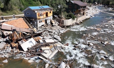
Late on September 26th, Hurricane Helene made landfall at category 4 on the Saffir-Simpson scale on the panhandle of Florida, bringing high winds, extreme rainfall and storm surges to coastal areas.
Over the next two days, it struck inland in a North-northeasterly direction, bringing torrential rainfall to a large region including most of Georgia, western North and South Carolina, eastern Tennessee and southern Virginia. This led to extensive and in many cases unprecedented flash flooding across many of these regions. At least 227 people were killed and nearly 2 million were left without power (AP News, 2024; CNN, 2024).
The influence of climate change on tropical cyclones is more complex compared to other types of extreme weather events as impacts are driven by both heavy rainfall and extreme winds. In addition, the surrounding conditions, in particular the sea surface temperatures in the Gulf of Mexico and wider basin, are crucial for the formation of hurricanes. Here, scientists from the United States, the United Kingdom, Sweden and the Netherlands, use several different approaches to investigate the influence of climate change on these different aspects of hurricane Helene, following the same approach as with Typhoon Gaemi that led to severe impacts in the Philippines, Taiwan and Hunan province of China earlier in the year, to analyse whether and to what extent human-induced climate change affected wind speeds and rainfalls associated with Hurricane Helene. For the assessment of the role of climate change in the heavy rainfall, we divide the most impacted region into two subregions, the coastal region encompassing 29.5-32 °N and 81.5-86 °W (figure 1.1) where Helene made landfall and caused 2 days of extreme rainfall, and the inland region, encompassing 34.5-38 °N and 80-85 °W (figure 1.1), in the Southern and Central Appalachians where the rainfall from the hurricane combined with an earlier heavy rainfall system and led to 3 days of unprecedented rainfall. To study the conditions that formed and fuelled Helene, we also analyse the role of climate change in high sea surface temperatures and potential intensity, a metric combining sea surface temperature, air temperature and air humidity data to predict maximum hurricane wind speeds.

Main findings
- Hurricane Helene formed in the Gulf of Mexico above record-hot sea surface temperatures (SSTs). In the days leading up to Helene’s landfall, a line of slow-moving storms formed along a stalled cold front, drawing in tropical moisture from Helene’s outer edges. This system, stretching from Atlanta through the southern Appalachian region, led to very heavy rainfall in the southern states and Appalachia even before the heavy rainfall associated with Helene arrived, leading to devastating flooding. Overall, at least 227 people died, the highest death toll from a hurricane in the mainland US since Katrina in 2005.
- In addition to the very heavy rainfall caused by the hurricane, and the preceding rain event, the steepness of the terrain funnelled rainwater into rivers and streams leading to extremely sudden flash flooding as high as rooftop levels making evacuations impossible in many regions.
- In today’s climate, that has already been warmed by 1.3 °C due primarily to the burning of fossil fuels, weather observations indicate that rainfall events as severe as those brought by hurricane Helene now occur about once every 7 (3 – 25) years in the coastal region, and about once every 70 (20 – 3000) years in the inland region.
- To determine the role of climate change in the rainfall we combine observations with climate models. In both regions, the rainfall was about 10% heavier due to climate change, and equivalently the rainfall totals over the 2-day and 3-day maxima were made about 40% and 70% more likely by climate change, respectively. If the world continues to burn fossil fuels, causing global warming to reach 2 °C above pre industrial levels, devastating rainfall events in both regions will become another 15-25 % more likely.
- The IRIS model was used to investigate Helene’s strong winds by analysing storms making landfall within 2 degrees of Helene. By statistically modelling storms in a 1.3°C cooler climate, this model showed that climate change was responsible for an increase of about 150% in the number of such storms (now once every 53 years on average, up from every 130 years), and equivalently that the maximum wind speeds of similar storms are now about 6.1 m/s (around 11%) more intense.
- The environmental conditions leading to a storm of Helene’s intensity were also studied. Using the same approach as for rainfall, we find that climate change increased the potential intensity in September around the track of Helene increased strongly in likelihood by a factor of 18. Using the Ocean Climate Shift Index, we find that the sea surface temperatures (SSTs) over the track of the storm have been made about 200-500 times more likely due to the burning of fossil fuels.
- Together, these findings show that climate change is enhancing conditions conducive to the most powerful hurricanes like Helene, with more intense rainfall totals and wind speeds. This is in line with other scientific findings that Atlantic tropical cyclones are becoming wetter under climate change and undergoing more rapid intensification.
- Hurricane Helene was very well forecast with the national agency NOAA urging media to warn people of “catastrophic and life-threatening” flooding and landslides across the Southern Appalachians. People in affected coastal regions were asked to evacuate ahead of the landfall of Helene. However, most of the deaths occurred farther inland, in the mountainous terrain where challenges such as spotty cell and internet services, limited experience with Hurricanes and more limited evacuation infrastructure have been reported in the media as leaving people feeling caught off guard.
- Along the inland path of Hurricane Helene a network of dams, and drainage systems exists, that has long been identified as highly exposed to hazards and in a general state of disrepair. A catastrophic dam failure was ultimately avoided, despite evacuations downstream of at least 3 dams warning of potential failure. However, current flood protection infrastructure is not accounting for heavy rain cascading into landslides and mudslides in mountainous regions, as happened in the inland region leading to the destruction of homes, businesses and roads.
- xxxxxxxxxxxxxxxxxxxxxxxxxxxx
Global heating makes hurricanes like Helene twice as likely, data shows
Damaged buildings in the aftermath of Hurricane Helene flooding in Bat Cave, North Carolina, on Tuesday. Photograph: Mario Tama/Getty Images Analysis shows Gulf’s heat that worsened Helene 200-500 times more likely because of human-caused global heating
As Hurricane Milton bears down on Florida, fueled by a record-hot Gulf of Mexico, a new analysis has shown how the Gulf’s heat that worsened last month’s Hurricane Helene was 200 to 500 times more likely because of human-caused global heating.
Helene, one of the deadliest storms in US history, gathered pace over the Gulf before crashing ashore with 140mph (225km/h) winds.
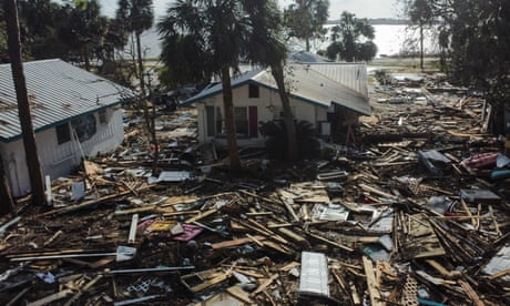
Double punch of hurricanes could become common due to climate crisis Read more The new analysis found climate change increased by 10% the amount of rainfall hurled down by the hurricane, which left more than 220 people dead across six states as it barreled north two weeks ago, flattening and drowning towns, tearing up roads and severing water supplies. It also made Helene’s winds about 13mph, or 11%, more intense.
The burning of fossil fuels has made storms as severe as Hurricane Helene about 2.5 times more likely than they were in the pre-industrial age, the multinational group of scientists at the World Weather Attribution group stated. Should the world warm by 2C above this pre-industrial period, which will occur without major cuts to emissions, storms such as Helene will get a further 10% more rainfall, the study found.
“The heat that human activities are adding to the atmosphere and oceans is like steroids for hurricanes,” said Bernadette Woods Placky, chief meteorologist at Climate Central, part of the attribution group, who added that storms like Helene and Milton were becoming “explosive” because of excess heat.
A study by Climate Central published on Monday found the sea surface temperature around Milton’s path was 400-800 times more likely because of the climate crisis.
“If humans keep heating the climate, we will keep seeing storms rapidly morph into monster hurricanes, leading to more destruction,” she said.
The speedy analysis of Helene comes before the impending landfall of Milton which also grew in strength over the Gulf of Mexico, stunning scientists by ballooning from a category 1 storm to a category 5 event, with maximum winds of 180mph, in just nine hours.
It is set to hit the Tampa area late on Wednesday, prompting dire warnings from the city’s mayor that residents will die if they don’t evacuate.
Both storms rapidly intensified over the Gulf, with researchers pointing to exceptional seawater heat as a key factor in fueling the hurricanes. Since this summer, the surface and deeper waters of the Gulf have been at record, bathtub-like temperatures, with Milton set to pass over a patch of water close to Tampa that is around 2-3C hotter than usual.
Hurricanes gain strength from hotter oceans and a warmer atmosphere, with this heat adding to the pace of the storms while also loading them with extra moisture that is then unleashed as pounding rainfall, causing the sort of catastrophic flooding that submerged communities as far inland as western North Carolina when Helene hit.
“The Gulf is still at an anomalously high temperature and when you have these warm temperatures you are more likely to get rapidly intensifying hurricanes,” said Brian McNoldy, a climate scientist at the University of Miami.

US south-east reels from ‘unspeakable tragedy’ of Helene as new storm looms Read more Other factors, such as countervailing wind shear that can dissipate hurricanes, are also important in storm formation but the Gulf’s lengthy fever has had experts increasingly concerned about the potential for events like Helene and Milton, McNoldy said.
“We were nervously waiting, wondering if a hurricane will take advantage of all this heat,” he said. “It’s like there was a powder keg, waiting for a spark. Now we have that spark. Milton is a remarkable storm, it’s exceptional in all history in terms of its intensification rate.”
Scientists noted that a warmer atmosphere is also able to hold more water vapor at a rate of about 7% per degree of warming. Currently, the world has warmed by at least 1.3C since the pre-industrial era and there are fears that this may be accelerating.
“What many people don’t realize is that only 1% of this extra heat is going into the atmosphere: so our records of global temperature only reflect 1% of the total increase in the earth’s heat content,” said Katharine Hayhoe, the chief scientist of the Nature Conservancy and a professor at the Texas Tech University. “Eighty-nine per cent of this heat is going into the ocean where it is contributing to rising sea levels, deadly marine heatwaves, and stronger and more rapidly intensifying hurricanes.”
Coming just a month before a US presidential election that has barely featured the climate crisis as a campaign issue, the twin hurricanes have provided US voters a stark reminder of the forces unleashed by a warming planet that can touch upon almost every aspect of life.
Donald Trump, who has called the climate crisis a “hoax” and a “scam” and has promised to slash environmental regulations for oil and gas companies in return for campaign donations, had to cancel an appearance in Miami this week because of Milton’s impact.
His opponent Kamala Harris, meanwhile, has acknowledged the dangers posed by global heating but has largely steered clear of the topic during rallies and interviews.
“Climate change is in our face right now and people are making that connection,” said Kathie Dello, the state climatologist for North Carolina, which was badly ravaged by Helene. “There’s this realization that we are seeing things we have never seen before, that we are vulnerable to climate change and we aren’t prepared for the impacts.
“Climate itself is never the No 1 election issue but the economy suffers from hurricanes, we have schools closed, people without food, shelter and water. Climate is all tied to that.”
The solution, according to the UN, is to halt the burning of fossil fuels. “Our future is in our hands,” says Hayhoe.
xxxxxxxxxxxxxxxxxxxxxxxxx
Hurricane Milton: JD Vance says "even Obama" better than Harris in a crisis
JD Vance Calls Out Amount Of Hurricane Funding At Campaign RallyJD Vance has called on the Biden-Harris administration to get "its act together" in a scathing critique of the government's disaster management as Hurricane Milton barrels towards Florida.
The Ohio Senator and Republican vice presidential nominee said that the incumbents' handling of recent natural disasters was worse than the Obama administration, and had resulted in undue suffering for the storm-hit communities across the Southeast. With only 26 days left in the close-knit presidential race, Vice President Kamala Harris's response to Hurricane Helene, the deadliest since Katrina, could prove decisive.
"The Biden-Harris response to Hurricane Helene, the deadliest storm since Katrina, has the people of the Southeast and especially Appalachia paying an extraordinary price for the administration's incompetence," Vance wrote in a Tuesday column for The Wall Street Journal.

Republican vice presidential nominee, Senator JD Vance, at Eastern Market, Tuesday, October 8, 2024, in Detroit. On Tuesday, Vance criticized the Biden-Harris Administration's "incompetent" response to Hurricane Helene. PAUL SANCYA/AP PHOTO Vance cited reports that the Democratic presidential nominee had skipped disaster preparedness briefings, which he called "a staple of the Trump Administration's disaster-response planning."
He mentioned the delayed deployment of troops by the Defense Department to the affected areas, which he said was damning for a disaster response in which "every second counts."
"A competent leader would have ordered those men and women into motion earlier, bureaucracy be damned," Vance wrote. "Ms. Harris and Mr. Biden treated the situation like a public-relations disaster instead of a real one."
"Even the Obama administration was better at deploying assets in disaster zones," he added, praising the Democratic former president's quick response to the 2010 Haiti earthquake.
Echoing comments made by former President Donald Trump last week, Vance highlighted concerns over the Federal Emergency Management Agency's ability to address this hurricane season, calling the agency another "victim of misplaced Biden-Harris political priorities."
"Under Ms. Harris and Mr. Biden, FEMA has funneled millions of dollars to nongovernmental organizations whose stated goal is facilitating mass migration into the U.S.," Vance said, referring to FEMA-administered programs to provide food and sheltering services for migrant arrivals into the country.

Roxanne Brooks mounts an American flag to a stack of cinderblocks outside her friend's destroyed mobile home in the aftermath of Hurricane Helene flooding on October 6, 2024, in Swannanoa, North Carolina. Many have called... More MARIO TAMA/GETTY IMAGES The dual effects of Hurricanes Helene and Milton have already been cited by many outlets as Harris's "October Surprise," a high-profile event that could impact the outcome of a November election.
Helene hit two of this race's critical swing states—North Carolina and Georgia—where polling shows former President Donald Trump and VP Harris battling it out for only a few thousand votes.
According to the latest FiveThirtyEight polling averages for Georgia, Trump has extended his lead over Harris by 0.2 points since Helene made landfall, now holding the state 48.4 percent to the vice president's 47.3.
In North Carolina, which suffered some of the storm's worst impacts, Trump's lead has grown from 0.1 to 0.9 points over the same period.
The extent of damage across the Southeast could also directly affect citizens' ability to vote, as many election offices closed following the storm and the safety of travel to polling locations remains uncertain. If not addressed swiftly, this could potentially disenfranchise large segments of the electorate.
Harris's response to the September hurricane, as well as the one imminently making landfall in Florida, may also have nationwide impacts if voters share Vance's assessment of her response.
A YouGov poll published Tuesday found that 42 percent of the 4,450 U.S. adults surveyed trusted Trump to do a better job than his counterpart (40 percent) in handling a natural disaster.
As this particular comparison will remain relevant at least until Hurricane Milton has dissipated, it could be a decisive factor in this year's election.
xxxxxxxxxxxxxxxxxxxxxxxxxxxxx
Opinion | Biden-Harris Mismanaged Hurricane Helene
Journal Editorial Report: A hurricane, dock strike and Mideast war collide. Photo: Mario Tama/Getty Images During times of crisis and war, presidential leadership is critical to cut through competing bureaucratic fiefs and protect Americans from death and devastation. The Biden-Harris response to Hurricane Helene, the deadliest storm since Katrina, has the people of the Southeast and especially Appalachia paying an extraordinary price for the administration’s incompetence.
Shortly after Helene made landfall in the U.S. on Sept. 26, Joe Biden was at his house in Rehoboth Beach, Del. Vice President Kamala Harris was flying between ritzy California fundraisers, hobnobbing with celebrities. Homeland Security Secretary Alejandro Mayorkas was in Los Angeles, presiding over an awards ceremony. Before the storm, Ms. Harris had blown off her disaster-response briefings, which were a staple of the Trump administration’s disaster-response planning. The lack of prioritization had real-world ramifications.


No comments:
Post a Comment