Palm Springs Desert Sun, at <https://ca.movies.yahoo.com/movies/pipe-dream-possibility-water-experts-224757586.html>
Introduction by dmorista:
The various problems being caused or exacerbated by Global Warming are becoming ever more obvious. In the Southwestern and Intermountain U.S., a well thought out and well engineered water impoundment, supply, and distribution system, largely built from 100 - 50 years ago, is now contending with conditions that could not have been predicted when most of the system was designed and built. The Colorado River system of impoundments, canals, and reservoirs is no longer able to supply the water demanded by the greatly increased urban population, grown to 40 million in recent years, and business and industrial water uses. And more significantly, in addition it cannot supply the amount of water that is used by modern day agricultural production operations, agriculture uses 80% of water supplied by Western Water projects, including the reservoirs at Lake Mead and Lake Powell. This article notes that recently a: “ …. retired engineer Don Siefkes of San Leandro, California, wrote a letter to The Desert Sun of the USA TODAY Network with what he said was a solution to the West's water woes: Build an aqueduct from the Old River Control Structure to Lake Powell, 1,489 miles west, to refill the Colorado River system with Mississippi River water. …. The letter and others with an array of ideas generated huge interest from readers around the country – and debate about whether the concepts are technically feasible, politically possible or environmentally wise.”
This article looks at some of the major issues and possible solutions their readers had brought up regarding the increasingly dire water situation in the Southwestern U.S. It also briefly discusses the fact that the problems associated with Global Warming / Climate Change both affect the Colorado River and are also worldwide in scope. The delivery is in a non-technical manner and is clearly understandable. I am appending comments of my own, about some of the main points that are taken up in the article, below after the article itself. The Article appears here immediately below.
“A Pipe dream, or a possibility? Water experts debate 1,500-mile aqueduct from Cajun Country to Lake Powell.”, Monday, August 15, 2022, Janet Wilson, Palm Springs Desert Sun -
Accessed at <https://ca.movies.yahoo.com/movies/pipe-dream-possibility-water-experts-224757586.html>
Text of the Article:
Two hundred miles north of New Orleans, in the heart of swampy Cajun Country, the U.S. Army Corps of Engineers in 1963 cut a rogue arm of the Mississippi River in half with giant levees to keep the main river intact and flowing to the Gulf of Mexico.

(Video that addresses some of the issues related to the water supply problems of the Colorado River)
The Old River Control Structure, as it was dubbed, is also the linchpin of massive but delicate locks and pulsed flows that feed the largest bottomland hardwood forests and wetlands in the United States, outstripping Florida’s better known Okefenokee Swamp.
Clouds of birds – hundreds of species – live in or travel through Louisiana’s rich Atchafalaya forests each year, said National Audubon Society Delta Conservation Director Erik Johnson. They include gawky pink roseate spoonbills, tiny bright yellow warblers, known as swamp candles because of their bright glow in the humid, green woods, and more.
This summer, as seven states and Mexico push to meet a Tuesday deadline to agree on plans to shore up the Colorado River and its shriveling reservoirs, retired engineer Don Siefkes of San Leandro, California, wrote a letter to The Desert Sun of the USA TODAY Network with what he said was a solution to the West's water woes: Build an aqueduct from the Old River Control Structure to Lake Powell, 1,489 miles west, to refill the Colorado River system with Mississippi River water.
A BODY IN A BARREL, GHOST TOWNS, A CRASHED B-29: What other secrets are buried in Lake Mead?

(Caption Above: Downstream of a Mississippi River control point in Louisiana's Cajun Country, bottomland hardwood forests are home to a richly diverse array of plants and animals that depend on regular water flows.)
“Citizens of Louisiana and Mississippi south of the Old River Control Structure don’t need all that water. All it does is cause flooding and massive tax expenditures to repair and strengthen dikes,” wrote Siefkes. "New Orleans has a problem with that much water anyway, so let’s divert 250,000 gallons/second to Lake Powell, which currently has a shortage of 5.5 trillion gallons. This would take 254 days to fill.”
The letter and others with an array of ideas generated huge interest from readers around the country – and debate about whether the concepts are technically feasible, politically possible or environmentally wise. Seeking answers, The Desert Sun consulted water experts, conservation groups and government officials.
Engineers said the pipeline idea is technically feasible. But water experts said it would likely take at least 30 years to clear legal hurdles. And biologists and environmental attorneys said New Orleans and the Louisiana coast, along with the interior swamplands, need every drop of muddy Mississippi water.
The massive river, with tributaries from Montana to Ohio, is a national artery for shipping goods out to sea. And contrary to Siefkes' claims, experts said, the silty river flows provide sediment critical to shore up the rapidly disappearing Louisiana coast and barrier islands chewed to bits by hurricanes and sea rise. Scientists estimate a football field's worth of Louisiana coast is lost every 60 to 90 minutes. Major projects to restore the coast and save brown pelicans and other endangered species are now underway, and Mississippi sediment delivery is at the heart of them.
Siphon off a big portion, and “you’d be swapping one ecological catastrophe for another,” said Audubon’s Johnson.
'My water, your water. My state, your state'
Nonetheless, Siefkes’ trans-basin pipeline proposal went viral, receiving nearly half a million views. It’s one of dozens of letters the newspaper has received proposing or vehemently opposing schemes to fix the crashing Colorado River system, which provides water to nearly 40 million people and farms in seven western states.
Fueled by Google and other search engines, more than 3.2 million people have read the letters, an unprecedented number for the regional publication's opinion content.
Many saw Siefkes' idea and others like it as sheer theft by a region that needs to fix its own woes.
CLIMATE POINT: Subscribe to USA TODAY’s free weekly newsletter on climate change, the environment and the weather
“Let's be really clear here. As a resident of Wisconsin, a state that borders the (Mississippi) river, let me say: This is never gonna happen,” wrote Margaret Melville. “What states in the Southwest have failed to do is curtail growth and agriculture that is, of course, water-driven."
But desert defenders pushed back. John Neely of Palm Desert, California, responded: "All of these river cities who refuse to give us their water can stop snowbirding to the desert to use our water. The snowbirds commonly stay here for at least six months. Do they thank us for using our water? No. Do they pay extra for using our water? No. They’re all such hypocrites. My water, your water. My state, your state. Last time I heard, we are still the United States of America."
Haul icebergs south? Manufacture rain?
Yahoo, Reddit and ceaseless headlines about a 22-year megadrought and killer flash floods, not to mention dead bodies showing up on Lake Mead’s newly exposed shoreline, have galvanized reader interest this summer.
But grand ideas for guaranteeing water for the arid West have been floated for decades. Haul icebergs from the Arctic to a new southern California port. Run a giant hose from the Columbia River along the bottom of the Pacific Ocean to refill Diamond Valley Reservoir. Grab hydrogen and oxygen from the air and make artificial rain.
'WE'RE GETTING FURTHER AND FURTHER BEHIND': Climate change exposes growing gap between weather we've planned for – and what's coming
As zany as the ideas may sound, could any work, and if so, what would be the costs?
Experts say there’s a proverbial snowball’s chance in August of most of these schemes being implemented. Physically, some could be achieved. This is the country that built the Hoover Dam, and where Los Angeles suburbs were created by taking water from Owens Lake. From winter lettuce in grocery stores to the golf courses of the Sun Belt, the West’s explosive growth over the past century rests on aqueducts, canals and drainage systems.
The bigger obstacles are fiscal, legal, environmental and most of all, political.
"The engineering is feasible. Absolutely. You could build a pipeline from the Mississippi or Missouri Rivers. Would it be expensive? Yes. Do we have the political will? Absolutely not," said Meena Westford, executive director of Colorado River resource policy for the Metropolitan Water District of Southern California. "I think that, societally, we want to be more flexible. We want to have more sustainable infrastructure. So moving water that far away to supplement the Colorado River, I don't think is viable."
She added, "But it's doable. You could do it."
In fact, she and others noted, many such ideas have been studied since the 1940s. Most recently, in 2012, the U.S. Bureau of Reclamation produced a report laying out a potentially grim future for the Colorado River, and had experts evaluate 14 big ideas commonly touted as potential solutions.
The concepts fell into a few large categories: Pipe Mississippi or Missouri River water to the eastern side of the Rockies or to Lake Powell on the Arizona-Utah border, bring icebergs in bags, on container ships or via trucks to Southern California, pump water from the Columbia River in the Pacific Northwest to California via a subterranean pipeline on the floor of the Pacific Ocean, or replenish the headwaters of the Green River, the main stem of the Colorado River, with water from tributaries.
A DISASTROUS 'MEGAFLOOD' IN SUNNY AND DRY CALIFORNIA? It's happened before.
While they didn’t outright reject the concepts, the experts laid out multi-billion-dollar price tags, including ever-higher fuel and power costs to pump water up mountains or over other geographic obstacles. They also concluded environmental and permitting reviews would take decades.
"To my mind, the overriding fatal flaw for large import schemes is the time required to become operational. A multi-state pipeline could easily require decades before it delivers a drop of water," said Michael Cohen, senior researcher with the Pacific Institute. He said the most pragmatic approach would only pump Midwest water to the metro Denver area, to substitute for imports to the Front Range on the east side of the Rockies, avoiding "staggering" costs to pump water over the Continental Divide.
But Denver officials have expressed skepticism, because Missouri or Mississippi water is of inferior quality to pure mountain water.
US can't 'engineer our way out' of drought
Not mentioned was the great granddaddy of all schemes for reallocating water, known as the North American Water and Power Authority Plan.
Developed in 1964 by engineer Ralph Parsons and his California-based Parsons Corporation, the plan would provide 75 million acre-feet of water to arid areas in Canada, the U.S. and Mexico. An acre-foot is enough water to serve about two households for a year, so it could supply water to 150 million customers.

(Caption above: Ralph M. Parsons designed a massive but never realized plan that would have redistributed water across North America.)
The total projected cost of the plan in 1975 was $100 billion – or nearly $570 billion in today's dollars, comparable to the Interstate Highway System. The project would require more than 300 new dams, canals, pipelines, tunnels and pumping stations. Its largest dam would be 1,700 feet tall, more than twice the height of Hoover Dam.
Parsons said the plan would replenish the upper Missouri and Mississippi rivers during dry spells, increase hydropower along the Columbia River and stabilize the Great Lakes. He proposed using nuclear explosions to excavate the system's trenches and underground water storage reservoirs.
TAPS HAVE RUN DRY IN A MAJOR MEXICO CITY FOR MONTHS: A similar water crisis looms in the U.S. too, experts say.
The U.S. Army Corps of Engineers, prodded by members of Congress from Western states, studied the massive proposal. Ultimately the rising environmental movement squelched it – the project would destroy vast wildlife habitats in Canada and the American West, submerge wild rivers in Idaho and Montana, and require the relocation of hundreds of thousands of people.
Environmental writer Marc Reisner said the plan was one of "brutal magnificence" and "unprecedented destructiveness." Historian Ted Steinberg said it summed up "the sheer arrogance and imperial ambitions of the modern hydraulic West."
In China, the massive South-to-North Water Diversion Project is the largest such project ever undertaken. Inspired by Mao Zedong, who in 1952 observed, "The south has plenty of water and the north lacks it, so if possible why not borrow some?" and planned for completion in 2050, it will divert 44.8 billion cubic meters of water annually to major cities and agricultural and industrial centers in the parched north.
When finished, the $62 billion project will link China’s four main rivers and requires construction of three lengthy diversion routes, one using as its base the 1,100-mile long Hangzhou-to-Beijing canal, which dates from the 7th century AD.
Meanwhile, watershed states in the U.S., and even counties have taken action to prevent such schemes.
The Great Lakes Compact, signed by President George W. Bush in 2008, bans large water exports outside of the area without the approval of all eight states bordering them and input from Ontario and Quebec.
Other legal constraints include the Endangered Species Act, the National Environmental Protection Act and various state environmental laws, said Brent Newman, senior policy director for the National Audubon Society's Delta state programs. A Mississippi pipeline to Lake Powell would need to cut across four states, he and Johnson said, including hundreds of miles of wetlands in Louisiana and west Texas.
THE U.S. IS MAKING A BIG DOWN PAYMENT ON CLIMATE CHANGE: Here's what needs to come next.
Large amounts of fossil fuel energy needed to pump water over the Rockies would increase the very climate change that’s exacerbating the 1,200-year drought afflicting the Colorado River in the first place, said Newman, who in his previous job helped the state of Colorado design a long-term water conservation plan. At comment sessions on Colorado's plan, he said, long-distance pipelines were constantly suggested by the public.
"Sometimes there is a propensity in areas like Louisiana or the Southwest, where we've had such success in our engineering marvels, to engineer our way out of everything," Newman said. "I don't think that drought, especially in the era of climate change, is something we can engineer our way out of."
'Arizona really, really wants oceanfront'
But big water infrastructure projects aren't just of interest to the general public.
Arizona, which holds "junior" rights to Colorado River water, meaning it has already been forced to make cuts and might be legally required to make far larger reductions, wants to build a bi-national desalination plant at the Sea of Cortez, which separates Baja California from the Mexican mainland. The resulting fresh water would be piped north to the thirsty state.
Such major infrastructure “is an absolute necessity,” said Tom Buschatzke, director of the Arizona Department of Water Resources, who said he “represents the governor on all things Colorado River.”

(Caption above: Will Thelander, a farmer with Tempe Farming Company, stands at a junction of two irrigation ditches at the farm outside of Casa Grande on August 13, 2021. The declaration of a water shortage on the Colorado River will cut the amount of water that Pinal County farmers receive from the Central Arizona Project Canal in 2022.)
Arizona's legislature allocated $1 billion in its last session for water augmentation projects like a possible desalination plant, and state officials are in discussions with Mexican officials about the idea, said Buschatzke.
The state also set aside funds in 2018 to study possible imports from the Missouri or Mississippi Rivers, but to date, the study hasn’t been done, he said.
Others said the costs of an Arizona-Mexico desalination plant would also likely prove infeasible.
"The desalination plant Arizona has scoped out would be by far the largest ever in North America," said Jennifer Pitt, National Audubon Society's Colorado River program director.
Pitt, who was a technical adviser on BLM's 2012 report, decried ceaseless pipeline proposals. "Nebraska wants to build a canal to pull water from the South Platte River in Colorado, and downstream, Colorado wants to take water from the Missouri River and pull it back across Nebraska. It boggles the mind. I can't even imagine what it would all cost."
'CLEAR THE LAKE IS IN TROUBLE': Great Salt Lake breaks record low level for the second time in a year amid drought
Westford, of Southern California's Metropolitan Water District, agreed. "Arizona really, really wants oceanfront," she chuckled.
But Westford and her colleague Brad Coffey contend desalination is needed in the Golden State. Despite the recent defeat of a major plant in Huntington Beach, after the California Coastal Commission said it was too environmentally damaging, "ocean desalination can't be off the table," said Coffey, a water resources manager.
California Gov. Gavin Newsom also touted desalination in a drought resilience plan he announced last week, though in brackish inland areas. All three officials said the construction of a 45-mile Delta Water Project tunnel to keep supply flowing from the middle of the state to thirsty cities in the south is vital. That project, which also faces heavy headwinds from environmentalists, would cost an estimated $12 billion.
Coffey said the project isn't really a pipeline, but more "a bypass for ... an aging 60-year-old" system.
Is this the time for a national water policy?
So what are the solutions to the arid West's dilemma, as climate change heats up and water resources dry up due to reduced snowmelt and rainfall?
Global water scarcity expert Jay Famiglietti said it's time for a national water policy, not to figure out where to lay down hundreds of pipes but to look comprehensively at the intertwining of agriculture and the lion's share of water it uses.
For him, that includes setting aside at least portions of the so-called "Law of the River," a complicated, century-old set of legal agreements that guarantees farmers in Southern California the largest share of water.

(Caption above: Atchafalaya Basin, fed by pulsed flows off the Mississippi River into the Atchafalaya River in Louisiana, is a critical stop on the Mississippi River flyway used by hundreds of species of birds.)
"Should we move the water to where the food is grown, or is it maybe time to think about moving the food production to the water?" said Famiglietti, a University of Saskatchewan hydrology professor who tracks water basins worldwide via NASA satellite data,
In southeastern California, officials at the Imperial Irrigation District, which is entitled to by far the largest share of Colorado River water, say any move to strip their rights would result in legal challenges that could last years. General Manager Henry Martinez also warned that cutting water to Imperial Valley farmers and nearby Yuma County, Arizona, could lead to a food crisis as well as a water crisis.
Martinez, an engineer who oversaw the construction of pipelines in the Sierra Nevada for Southern California Edison, agrees a 1,500-mile pipeline from the Mississippi could physically be built.
But, he said, the days of mega-pipelines in the U.S. are likely over due to lack of environmental and political will.
Janet Wilson is senior environment reporter for The Desert Sun, and co-authors USA TODAY's Climate Point newsletter. She can be reached at jwilson@gannett.com or @janetwilson66 on Twitter.

(Caption Above: After years of very little rainfall, the lagoon sits dry and cracked in Suesca, Colombia, Feb. 17, 2021. The basin which is dependent on runoff has suffered severe deforestation and erosion, which together with the added impact of climate change has led to a significant reduction of its water level.)
End of Text from the article that appeared on Monday, August 15, 2022, by Janet Wilson, in the Palm Springs Desert Sun
My Comments, dmorista:
There are only 4 actual potential sources of New Water for places like the U.S. Southwest. They are: 1). Weather modification that consists of attempts to increase rainfall in specific areas by atmospheric manipulations; 2). Desalination of Ocean Water; 3). The standard engineering projects that move water from wetter places to drier ones by means of dams, aqueducts, and reservoirs, and; 4). The capture and harvesting of icebergs. The other main approach is to improve the efficiency of water usage in the region itself.
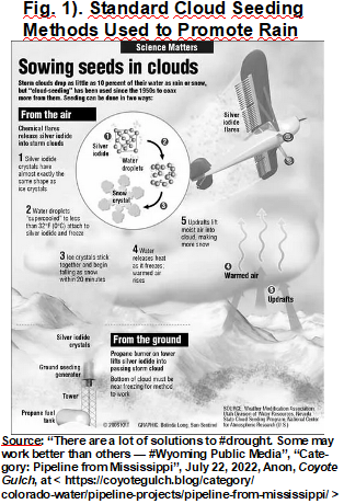
1). Weather modification that tries to direct rainfall to dry areas is in its infancy and is not yet particularly reliable nor is it without its detractors; as rain that falls in one place due to weather modification actions, likely used to fall somewhere else. There is a lot of secretive work going on in that area of science. Seeding clouds and attempting to increase the rainfall in some areas is still difficult and unpredictable. I am not aware of the extent to which military research into weather modification has proceeded to levels of proficiency not known to the general population. But the basic technique is to seed an area of the atmosphere with tiny particles, usually of silver iodide, that serve to mimic the types of particles that water attaches to building the ice crystals that are the first part of producing precipitation.
2). Desalination is a potential source but it has its own set of environmental problems; and the water produced is relatively expensive. Desalinated water is generally considered to be affordable for urban, and perhaps industrial, uses. But most experts say it is far too expensive to use in agricultural applications. Desalination is already in use in arid urban areas and produces reliable water supplies. It is, in general, energy intensive and environmentally sound ways to dispose of the brine that is created as a by-product is a serious environmental problem. In the U.S. Southwest California already has a couple of desalination facilities that provide Southern California with municipal water supplies. Various places in the desert areas of the Middle East, and some well-off places in East Asia, and a few other places currently desalinate water.
3). Standard engineering approaches, including dams, aqueducts, and reservoirs, have long been used by humanity to move and control water. As for an enhanced system of moving water in the Southwest U.S. there are just a few realistic potential sources of water. These include the Columbia River that flows along the state border of Washington and Oregon. And we can be sure that people in that area would fiercely oppose such an initiative. Then there are the Great Lakes, where the 8 states with Great Lakes shoreline and the Canadian Province of Ontario, have already organized to prevent movement of Great Lakes water to other regions. By 2008 these 8 states and Ontario formed the Great Lakes Compact and Alliance, a political organization that includes eight U.S. states and Ontario. The Great Lakes Compact was formed specifically to build a formidable legal barrier to removing water from the Great Lakes Basin.
The Mississippi River diversion is specifically discussed in the article above. It certainly carries a large flow of water, particularly in wet years; though there are periods of drought in the Mississippi River Basin when flows are greatly reduced.. However, even the pipeline proposed to carry Mississippi River water to the reservoirs of the parched SouthWest is dwarfed by some earlier proposals to divert water from the wetter parts of North America to the drier areas. Canada is the best endowed nation on Earth when it comes to freshwater resources. The prospect of moving water from the water surplus northern part of the continent, mostly in Canada, to the water shortage areas has stimulated various plans.
Two proposed plans stand out. The article above discussed in some detail The North American Water and Power Alliance plan (or alternatively the North American Water and Power Authority plan) {NAWAPA}. It was first proposed by the U.S. Army Corps of Engineers in the 1950s. The article notes that in the early to mid 1960s Parsons Engineering, led by Ralph M. Parsons developed that concept into a more comprehensive plan. If built, the project would have delivered 75 million acre feet per year (enough water for 150 million water customers) to dry areas in the U.S. Southwest and in Northwestern Mexico. To achieve this the project proposed building 369 various new structures, some extremely massive, and using nuclear explosions for excavating large trenches and underground reservoirs. Various sections would have been used to feed the Mississippi - Missouri River and the Columbia River, to move water down to the Colorado and Rio Grande Rivers, to restore the already depleted, in the 1960s, Ogallala Aquifer, and there was a plan to deliver water to Baja California and Sonora, Mexico. It also envisioned a navigable canal to connect Alberta, Canada with Lake Superior. Tremendous amounts of energy would have been needed to move the water to the South. One proposal included building 6 nuclear power plants to provide the electricity needed to pump the water across mountain ranges. Below are two maps of the NAWAPA plan.

(Source: “North American Water and Power Alliance”, n.d., anon, Wikipedia, at < https://en.wikipedia.org/wiki/North_American_Water_and_Power_Alliance >)

A very different, although of similar magnitude, plan the Great Recycling and Northern Development Canal, {GRAND} ), was first proposed and designed by a Canadian

(Source: “North American Water and Power Alliance”, n.d., anon, Wikipedia, at < https://en.wikipedia.org/wiki/North_American_Water_and_Power_Alliance >)
engineer from Newfoundland, Thomas Kierans, in 1959. Kierans proposed building a dam somewhere across James Bay in Northern Canada. James Bay is the southern
extension of Hudson Bay and has a huge amount of freshwater flowing into it from a number of Northern Canadian Rivers, and therefore has relatively low salinity.. Kierans' proposed dam, equipped with outflow only gates would have, after a few years,
established a huge freshwater lake in James Bay. Meanwhile the saltiness of the remaining body of Hudson Bay would have been significantly increased. Kiernans envisioned building one canal or pipeline from the southern tip of James Bay (renamed Lake James) to Lake Huron; and from the Great Lakes to a similar set of water short regions in North America. The amount of construction of dams, canals, reservoirs, and other installations would have been somewhat less than for NAWAPA. But there would still have been massive construction and electrical generation needs, to pump water uphill. Two Maps of GRAND are here, one above the other below.
(Source: “Great Recycling and Northern Development Canal”, n.d., anon, Wikipedia, at < https://en.wikipedia.org/wiki/Great_Recycling_and_Northern_Development_Canal >)

The current drought and record low levels of water in the various reservoirs, most notably Lakes Powell and Meade, have stimulated calls for a simpler and more modest, albeit still massive, project to carry water from the Mississippi River to the Colorado River system and on to, feed Lakes Powell and Meade. There have been a variety of projects proposed. Most take the water from around the middle of the Mississippi Rivers run somewhere in Missouri or Iowa. The plan discussed in the article “A Pipe dream, or a possibility? Water experts debate 1,500-mile aqueduct from Cajun Country

to Lake Powell.”, posted in the Palm Springs Desert Sun, is one example of these sorts of plans. Another article reported that: “The hypothetical Mississippi River pipeline, which gained new life last year amid devastating drought conditions, is a case in point. The basic idea is to take water from the Mississippi River, pump it a thousand miles west, and dump it into the overtaxed Colorado River, which provides water for millions of Arizona residents but has reached historically low levels as its reservoirs dry up. The Arizona state legislature allocated seed money toward a study of a thousand-mile pipeline that would do exactly this last year, and the state’s top water official says he’s spoken to officials in Kansas about participating in the project.” Finally the Mississippi River Water is of dubious quality, certainly far lower than the quality of the snow melt water that the Colorado River Basin reservoirs and water users are accustomed to. (See, “Pipe dreams: Why far-fetched Western water projects won’t go away”, Aug 15, 2022, Jake Bittle, Grist, at < https://grist.org/agriculture/drought-water-pipeline-cost-west-solution-infrastructure/ >)
Any sort of giant engineering proposal to build a system of dams, aqueducts, pipelines, and reservoirs to move water from one part of North American to another would cost billions of dollars, would cause all sorts of environmental damage in building and operating it, and would raise all sorts of political opposition, particularly in the area that
the water is to be taken from. An absolute baseline rock bottom figure for building such

a water diversion project to move Mississippi River water to the west was estimated in a
Bureau of Reclamation report, in 2012, to be $14 billion (in 2012 dollars, $18.1 billion in
2022 dollars), and furthermore the Bureau estimated it would take 30 years to complete. Real costs would reliably be expected to increase dramatically over that figure, and the Mississippi River diversion project price might have been seriously underestimated.. Years earlier, in 1982, a proposed pipeline to carry water from Lake Superior to Yankton, South Dakota was priced out at $26 Billion and an engineering study projected that 6 Thousand MegaWatt power stations would be needed to pump the water from the Western end of Lake Superior to Yankton. That would be $79.8 Billion in 2022 dollars.
The crux of the issue for the U.S. is the massive transfer of population over the past 70+ years from the NorthEast and Great Lakes regions to the South and the West, particularly the Southwest. The South suffers from droughts but more so from flooding and tropical storms. For basic geographical reasons the West is not anywhere near as well endowed as the East is with water resources. And what is more, much of the Colorado River Basin, particularly the Southern section where 40 million people now live, is both very dry and very hot. Land speculators and developers have marketed their products for a couple of generations now, many of those customers being people
Figure 2: “Back Off Suckers”, a Billboard From Michigan in 2001

(Figure 2 source: “Great Lakes”, Diversion of Great Lakes Waters / Future of the Great Lakes, Water Encyclopedia, at < http://www.waterencyclopedia com/Ge-Hy/Great- Lakes.html >)
leaving the Northeast and the Great Lakes regions. The great majority of residents of the Mississippi River area and the Great Lakes are not eager to see their water resources taken to the desert Southwest. The Billboard shown above was one of several erected around Michigan, during an earlier water diversion controversy in 2001. It is worth noting that a figure representing Arizona is not present on the Billboard.
Here we can contrast the approaches of Nevada and the city of Las Vegas, with the approach of the State of Arizona and its urban areas, particularly the Phoenix area.
Las Vegas has the most effective water conservation program in the U.S. and one of the best in the entire world. New housing developments in Las Vegas do not allow for large water thirsty lawns, and the city pays property owners in older areas to remove their lawns and use low water intensity xeriscaping instead. Despite explosive urban growth in the urban area, the actual amount of water used by Las Vegas has gone down in recent years. Phoenix has not taken anything like the measures Las Vegas has, and large expanses of water thirsty landscapes are still the norm. Aerial photography in

Southern California, another desert region, demonstrates that in all the middle class and upper middle class neighborhoods in that region of the state's cities nearly every house has a swimming pool, in addition to a large lawn. Phoenix and its suburbs are home to nearly 200 golf courses, only some of which feature desert landscapes (with lush green grass in the putting areas). As the Visit Phoenix website says about the desert style golf courses: “No matter which golf course you choose, you'll be getting some gorgeous greens. But if you still want that Sonoran Desert feel, tee off at spots such as …. ”. (See “Golf Courses in Phoenix”, “Golf Courses in Phoenix with Desert Landscapes”, Visit Phoenix, at < https://www.visitphoenix.com/things-to-do/outdoors/golf/ >)
In response to a letter published in the Desert Sun, on July 15, 2022, that stated in part that: “All of these river cities who refuse to give us their water can stop snowbirding to the desert to use our water. The snowbirds commonly stay here for at least six months. Do they thank us for using our water? No. Do they pay extra for using our water? No.”, another correspondent wrote in part that:
“I think the West needs to solve its own problems without making problems for other regions at a huge cost. Who is going to pay for the water transfer anyway? Certainly, Midwesterners don't want to. A few suggestions for Western states:
Stop building golf courses that use tons of water and get rid of most of them.
Stop planting grass and plants that don’t belong in a desert and watering them day and night to grow
Replace water parks with something that fits into a desert area
Stop developers from building more homes and promising 100 years of water usage. Obviously, you are running out much sooner. City planners are not doing a good job about growth and water management in a region that was way overbuilt 20 years ago.
Reduce the asphalt and concrete poured to make roads and parking lots. No trees or greenery certainly doesn’t keep things cooler.
“Westerners come to the Midwest in summer and use the lakes there to cool down. So the comment about Midwesterners coming West to escape cold is a two-way street.”
(See, “Snowbirds want to winter in the desert, but balk at sharing water? What hypocrites”, Letters, July 15, 2022, John Neely, Desert Sun, at < https://www.desertsun.com/story/opinion/readers/2022/07/19/snowbirds-winter-desert-but-balk-sharing-water-hypocrites/10088255002/ >: and “Here are 5 things the drought-parched West could do before taking Midwestern water”, Letters, July 25, 2022, Germaine Juneau, Desert Sun, at < https://www.desertsun.com/story/opinion/readers/2022/07/25/5-things-drought-west-could-do-before-taking-midwestern-water/10142165002/ >)
4). Icebergs and Iceberg Harvesting. It would appear that the best option for desert cities, or other areas that want to obtain freshwater supplies, might be to tow icebergs that have broken away from Greenland or Antarctica. That would enable those places to recover that freshwater that, with the increasing warming of the Earth and the retreat of the ice sheets on Greenland and Antarctica, is moving into the Oceans and melting there at an increasing rate. A significant proportion of that freshwater could be recovered by towing the icebergs to places that need freshwater supplies. This method was considered by various scientists, engineers, commissions and politicians, at numerous times during the past; including by Saudi Arabia back in the 1970s. This process would perhaps be viable for various other dry places, that have the financial and technological wherewithal to actually accomplish such a feat.1
Every year more glacial ice breaks off into the oceans than the total human usage of water. Is it possible to actually accomplish the use of icebergs? If it is, then first it would be possible to move icebergs to places in the Southern Hemisphere like Australia and South Africa. It turns out that the very nature of the ice in the icebergs from Antarctica is different from, and more conducive to, successfully moving icebergs than is that of Arctic / Greenland icebergs. Antarctic iceberg ice is colder, denser and more laminar than that of the icebergs in the Northern Hemisphere. It would only be possible to move icebergs long distances by using the currents to provide most of the energy to move the icebergs, and the main work of powerful tugs would be to steer a given iceberg into a given current. For icebergs generated in Antarctica the Benguela Current provides the energy needed to assist in moving them northward towards Africa. Many critics claim that it will never be possible to successfully move a major iceberg from the Southern Hemisphere, across the equator to any destination in the Northern Hemisphere. But that skepticism is not universal and a 1973 study carried out for the National Science Foundation discussed procedures to successfully move Antarctic Icebergs to Southern California. There are also many skeptics who point out that the Carbon footprint of a major iceberg towing / moving operation would be massive. The great majority of the world’s people live in the Northern Hemisphere and there are many places in the Northern Hemisphere that could make use of iceberg water. The icebergs of the Arctic / Greenland area are not as favorable for towing / moving as the Antarctic icebergs are; but there have been serious proposals to move them, including one to move an iceberg from Greenland to the Canary Islands off the coast of Africa. Harvesting icebergs is worth a serious new look as the alternatives, continued surface water development and transfer, ground water usage, desalination, and improved water efficiency and reuse efforts all have limitations.2
Serious water issues that we certainly face on a global basis, require innovative and serious solutions. Maybe what is needed is an international effort, that would build a fleet of nuclear powered heavy tugs specifically designed to move icebergs. If those tugs worked for years towing and guiding icebergs the carbon footprint involved in the manufacturing of a dedicated purpose built fleet of tugs would be minimal when compared to the good their work could do. A small fraction of the money spent on war, prisons, and repression could easily fund such a venture. And it would be far cheaper and more humane to provide water, and build the infrastructure to distribute it, to the poor places in the Global South with water shortage problems than to continue to battle the ongoing migration flows. Adequate water to live a wholesome life would be a big start towards reducing the push factors that propel many migrants to leave their homes.
Iceberg docking facilities would need to be constructed, and tied into existing water distribution systems, in port cities that are located in or near water shortage areas. Glacial / iceberg water is of excellent quality and would not need any purification treatment. It is of better, often far better, quality than are the water sources used by most places now.
(Sources for the first 3 paragraphs about harvesting Icebergs are: Notes 1). & 2). “The Many Failures and Few Successes of Zany Iceberg Towing Schemes”, Aug 2011, Alexis C. Madrigal, The Atlantic, at < https://www.theatlantic.com/technology/archive/2011/08/the-many-failures-and-few-successes-of-zany-iceberg-towing-schemes/243364/ >: “As South Africa faces ever more severe water shortages, some experts are seriously considering a proposal to harvest Antarctic icebergs and haul them to Cape Town. What are the chances it will succeed?”, Sep 21, 2018, Tim Smedley, BBC Future, at < https://www.bbc.com/future/article/20180918-the-outrageous-plan-to-haul-icebergs-to-africa >: “This Country Wants to Tow Icebergs From Antarctica to the Middle East As early as 2018”, May 5, 2017, Robbie Gramer, Foreign Policy – The Caistble, at < https://foreignpolicy.com/2017/05/05/this-country-wants-to-tow-icebergs-from-antarctica-to-the-middle-east/ >: “An engineering firm wants to tow icebergs thousands of miles from Antarctica to quench the driest areas of the world — and it's starting with Dubai”, Sep 8, 2018, Jeremy Berke, Business Insider, at < https://www.businessinsider.com/engineering-firm-tow-icebergs-antarctica-for-water >: Antarctic Icebergs as a Global Fresh Water Source, Oct 1973, J.L. Hult & N.C. Ostrander, Rand Corp., National Science Foundation.)
The Physical Reasons for the Increasingly Hot and Dry Conditions in the American Southwest
The American West is largely dry because of the size of the mountain ranges in the Sierras, Cascades, the Rockies and a couple of other ranges. The Western Mountains are considerably higher than the Appalachian Mountains of the East. Pacific Moisture

causes considerable precipitation over the Pacific Northwest. Map 8 shows the naturally humid and high precipitation areas of the Pacific Northwest. The moisture from the Pacific falls in the Naturally Humid Area as moist air rises and cools down; eventually causing the moisture to form ice crystals that turn into rain as they fall through the atmosphere, over the coastal mountain ranges. Then the air, that is now dry, descends, on the eastern side of the coastal ranges warming as it descends and actually sucking moisture out of the ground. This creates extremely dry conditions
The eastern slopes of the Rockies have limited areas that receive considerable precipitation and support forests, but the forested areas are neighbored by extremely dry areas on the western slopes due to the phenomena discussed above. These areas, that are humid enough to support forests composed of trees that have lower water requirements than the sorts of trees that grow in the Coast Range forests, have a mix of forested and arid or semi-arid regions.. .

The Intensification of the Situation by Global Warming
The American S.W. was always dry, at least in historical epochs going back for millions of years. But with the advent of human industrialization and the emission of billions of tons of Green House Gases (GHGs) the severity of the droughts (as well as of intense rain storms in humid regions) have increased. This is not just affecting the U.S., and in fact droughts are occurring over large portions of the globe.

These regions include large areas over the oceans of the world as well as over land. The most severe regions of drought over land are in SubSaharan Africa (see Map 9B) and in South America (see Map 9A). There is a huge area of drought over the Equatorial regions of the Pacific Ocean and over the south Pacific Ocean west of southern South America (see Map 9A). The severity of the drought over the Western U.S. is less, though is still extremely serious. It is the relatively large population living in desert regions of the southwest U.S., and the high levels of water usage in those regions, that make the problems particularly acute there. Unlike most desert regions on the face of the Earth the U.S. Southwest has been the focus of intensive development for over 100 years (if we include Southern California).

Over the last 20 years Southern California, the southern ⅔ of Nevada, nearly all of Arizona, and the Southwestern part of Colorado have been experiencing a severe drought. The amount of precipitation has varied in the Southwest during the past 120 years. From about 1900 - 1940 there was sufficient precipitation that compared favorably to the average for the 120 year period. Then from 1940 - 1970 were dry with lower than average precipitation. Then from 1970 - 1990 precipitation was above average, and from 1990 onward the area, composed of Southern California, Southern Nevada, all of Arizona, and Southwestern Colorado has been relatively dry. The 1940 - 1970 dry period was more widespread than the present situation is, according to the maps recently released by NOAA, Climate.gov. (See “U.S. Annual Precipitation Compared to 20th Century Average”, Map Set of 10 maps, 1901- 2020, Climate.gov Media, NOAA, at < https://preview.climate.gov/media/13465 >).
The system of water collection, from the high mountains of the Interior West to be carried southward, most of it used for decades to support urban areas and industrial scale agriculture in California was a marvel of water use. The water was primarily collected from snow pack in the higher elevations and did not arrive in California until when it was needed in the summer. This minimized evaporative losses while the water was stored in the, often sizzling hot and dry atmospheric conditions in Lakes Meade and Powell.

Population Distribution in North America
The population of the U.S. is distributed with 80% living east of the 98th Meridian. This is primarily a result of the availability of water. In the eastern half of the U.S. and in the Humid Zone of the Pacific Northwest there is adequate water to support cities, towns, agriculture, and rural residents with minimal engineering or irrigation help. The U.S. can be roughly divided into 3 regions. The East with 250 million inhabitants; the Pacific Coastal Zone with 50 million inhabitants of whom about 30 million or more actually live in areas where water must be imported, this includes Southern and Central California and includes the San Francisco Bay urban area that imports water from the Sierra Nevada mountains; and the Interior West that has 30 million residents, of whom a large proportion live in urban areas that are supplied with imported water. This situation is displayed graphically in Map 11, below.

Class Analysis of the Manipulation and Allocation of Water Resources
The Current Crisis involves low reservoirs in California and in the Colorado River Basin, Lakes Powell and Meade. The result is a lack of water for various uses primarily agricultural irrigation and high end urban uses such as private swimming pools and lavish golf courses; it also includes a lack of water for electricity produced by hydrological power generation at Lakes Meade and Powell, in a region with extremely high temperatures for half the year or more. The resultant shortages of electric power will likely fall hardest on the poor of the S.W., as the well-off are supplying themselves with stand-by generators and solar power installed on their roofs. This is a situation that took over 70 years to develop and is largely a result of the shift of economic and political power from the old core industrial and urban regions of the Northeast, the Great Lakes, and the Midwest, to the South and the Southwest. The last great period of U.S. infrastructure building, during the New Deal period, and later after WW 2 provided the water control systems and the highway and airport systems that connected the cities of the West with the world and provided them with copious supplies of water.
A significant portion of the U.S. ruling class decamped from New York, Chicago, and other Northeastern, Great Lakes, and Midwest cities during this period, to live a life richly supplied with sunbelt amenities. This transformation, at least after the mid-1970s, coincided with the deindustrialization of the U.S., the increasing power of the Military Industrial Complex, and the dominance of Finance Capital. The greatest irony is that the industrial workers of Detroit, Cleveland, Newark, Philadelphia and a host of other old industrial cities were taxed to provide the footloose elites with their emerging sun-drenched tennis and water skiing havens. Just as the top marginal income tax rates were cut during the Reagan Regime, from 63% down to around 30%, the most reactionary elements of the U.S. ruling class financed their move to the South and the West with money extracted from the left-behind industrial workers, most of whom would lose their jobs sooner or later.
The rising clamor pits upper and upper middle class residents of places like Phoenix and Tucson against people of more modest means in the Eastern part of the U.S. These proposals for moving water to the Colorado River Basin, typically increase during periods of drought. In this case the main impetus is to try to take water from the Mississippi River, or less likely but still conceivable an attempt to take water from Lake Superior (that would be of far higher quality than the Mississippi River water). The political resistance and environmental consequences of such a project, when combined with a multi billion dollar, perhaps a multi hundred billion dollar price tag, make the likelihood of actual construction seem to be pretty remote. But we should never stop being vigilant against such projects. Hopefully the Arizona Land Speculators and property developers can line up to support a desalination operation in Mexico on the shores of the Sea of Cortez.
No comments:
Post a Comment