“Middle class Americans are moving straight into fire and drought because they can't afford to live in the cities that are safer from climate change”, Aug 15, 2023, Eliza Relman, Insider, < https://www.businessinsider.
“More People Are Moving In Than Out of Areas Facing High Risk From Climate Change”, August 25, 2021, Lily Katz & Sebastian Sandoval-Olascoaga, RedFin News, at < https://www.redfin.com/news/
Introduction by dmorista: The general move of the U.S. population, away from the Northeastern Quadrant of the country to the South and Southwest has been underway for decades. But the South and Southwest are much more vulnerable to “natural” disasters and hazards. The massive fire that consumed much of the Hawaiian Island of Maui just serves to accentuate the dangers. The move South and West continues, an article published by The Atlantic just yesterday began:
“When it gets hot enough, as it has across the South in recent weeks, barefoot toddlers suffer second-degree burns from stepping onto concrete. People who fall on the blistering pavement wind up with skin grafts. Kids stay inside all day, 'trying to survive.' Windshield wipers glue themselves in place, and the ocean transfers heat back into your body. One electric blackout could bake thousands to death inside their homes.
“You would think people would flee such a hellscape expeditiously. But as record-breaking heat fries the Sun Belt, the region’s popularity only grows. The numbers, laid out recently in The Economist, are striking: 12 of the 15 fastest-growing cities in the U.S. are in the Sun Belt. Of the top 50 zip codes that saw the largest increases in new residents since the start of the pandemic, 86 percent were in blazing-hot Texas, Florida, and Arizona.” (See, "Why People Won’t Stop Moving to the Sun Belt", August 15, 2023, Olga Khazan, The Atlantic, at < https://www.theatlantic.com/
The state that had the biggest overall population gain due to migration, over the last century, is undoubtedly California. But after a century of people moving there in large numbers California has been profoundly changed and people are now leaving the state. California, with its moderate coastal climates, benefited both from the “clean air and amenities” migrations from the 1920s – 1970s, and from governmental and corporate investment for many years. In contrast, nobody ever moved to Texas to enjoy the climate; that can feature harsh cold spells in the winter (albeit not that stay around for long periods of time), and stifling hot humid summers that do last for months. Arizona, which is largely a desert, has nice moderate winters but blazing-hot summers. The Phoenix Metro area is the hottest urban area in the U.S. and its summers are genuinely dangerous to human well-being; and BTW Phoenix is entering into a period of extreme water problems, in fact some parts of the Phoenix Metro area are not issuing any new housing construction permits unless a reliable source of water can be demonstrated. Florida also has hot humid summers and is prone to hurricanes, floods, and severe thunderstorms (it has the most lightning of any place on Earth).
The reason that middle class people are still moving, in relatively large numbers, to Texas, Florida, and Arizona (along with several other Southern states) is that there are jobs there. Also housing is much more affordable than in the more moderate climate regions of the Pacific Coastal area or in the Atlantic Coastal area. Rabid Right-wingers and Forced-Birth advocates actually think, and loudly proclaim, that people are moving to the Authoritarian Neo-Confederate states specifically so they can live under Reactionary / Theocratic rule; and so dictatorial government officials can intervene in the most intimate and vulnerable aspects of their lives. I actually heard such a sentiment expressed on some Catholic Radio show, and reactionaries frequently blather on similar pronouncements.
The American Left has to come to grips with the never-ending move of the U.S. population to the Sunbelt. Some analysts predict that upcoming climate related disasters will begin a move back to the North as the South and Southwest become uninhabitable. So far there is absolutely no evidence of such a change. There is a trickle of professionals leaving places like Texas and Idaho to protect themselves from the Forced-Birth and Transgender repression regimes. The situation in Idaho is becoming dire as Ob Gyns are leaving or planning to leave Idaho in large numbers. But lower skilled people have no choice, if they move they go to where their work takes them.
The Insider Article is shorter and hits the main points. The RedFin News article is much longer and presents considerable amounts of data.
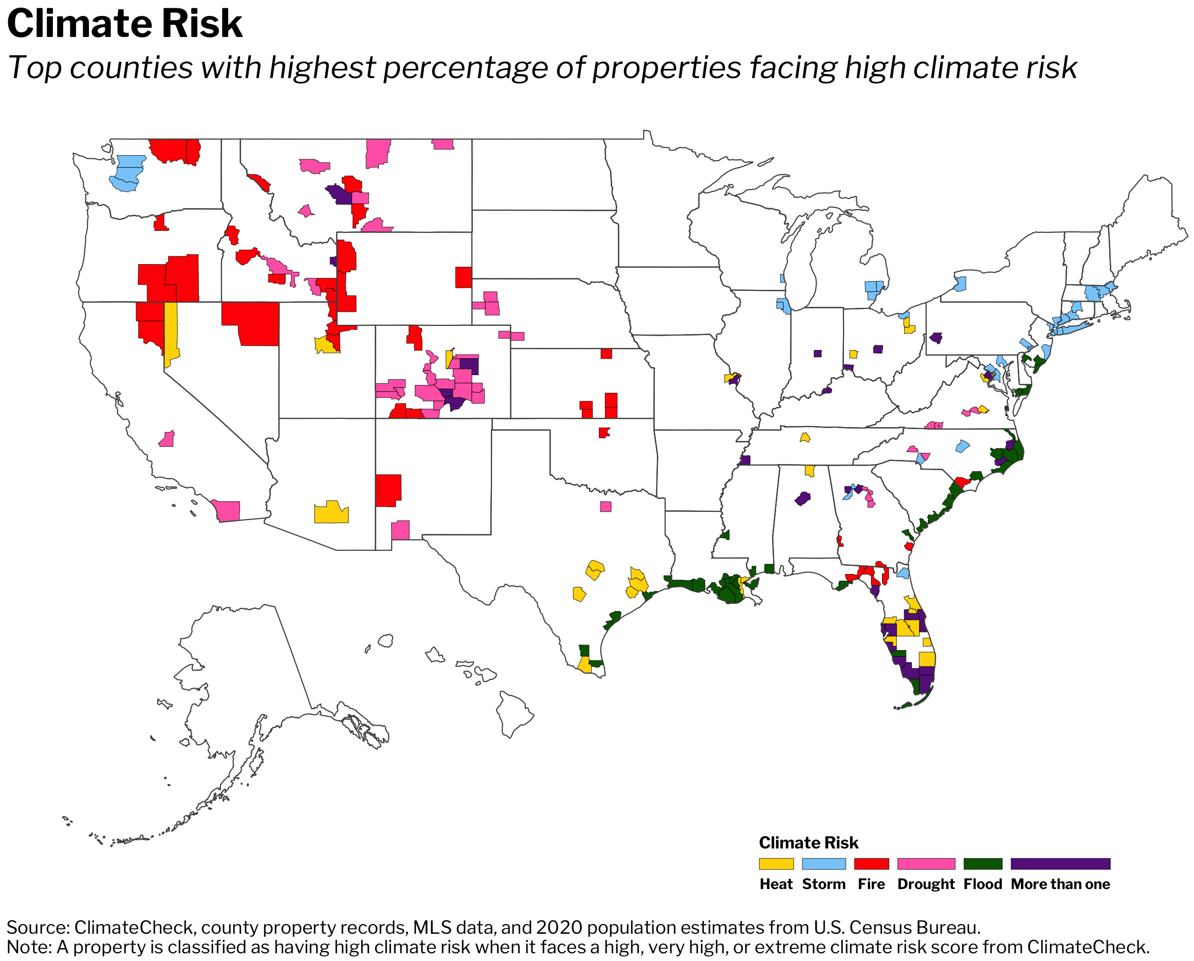
Below is a Map that shows percentage changes in the populations of U.S. Counties. The bias towards moving to the South and Southwest is obvious.

Middle class Americans are moving straight into fire and drought because they can't afford to live in the cities that are safer from climate change
An aerial view of homes in the Phoenix suburbs on June 9, 2023 in Queen Creek, Arizona.
An aerial view of homes in the Phoenix suburbs on June 9, 2023 in Queen Creek, Arizona.
Rising housing costs have helped push Americans into parts of the country more vulnerable to climate change.
US counties that have the most at-risk homes are all growing in population.
The trend shows how the burden of climate change is falling disproportionately on less affluent people.
The skyrocketing cost of housing has pushed many Americans to trade their lives in big coastal cities like New York and San Francisco for more affordable ones in Sunbelt cities and Southern suburbs.
But that move could cost more in the long-run.
These more affordable regions of the country are also facing much more severe impacts of climate change, including extreme heat, wildfires, floods, and droughts. People are pouring into flood-prone Florida, moving into Houston not long after Hurricane Harvey devastated the city in 2017, and relocating to parts of the West and Southwest dealing with the worst droughts and wildfires in the country.
Rather than leaving areas at high risk of natural disasters and other climate issues, more Americans are moving into them. US counties that have the most at-risk homes are all growing in population, while those with the fewest at-risk homes are almost all losing residents, according to a 2021 Redfin analysis.
The pandemic exacerbated this trend. There's been a recent spike in people moving from more expensive cities to lower-cost, smaller places farther from large metros and closer to natural amenities, in part due to the rise in remote work. These locations – like Bend, Oregon, which is vulnerable to wildfires — tend to be more at risk of natural disasters. The number of loan applications for homes in high-risk areas rose from 90,462 in February 2020 to 187,669 in February 2022, Freddie Mac reported.
In the longer-term, this trend will put many more Americans at risk of losing their homes to wildfires and floods, or being hurt or killed by extreme heat, or suffering from a lack of water. Rich people are already better able to protect themselves from natural disasters and other climate impacts, whether by fleeing, hiring private firefighters, or retrofitting their homes. But if lower-risk cities continue to price people out, the burden of climate change will fall even more disproportionately on less affluent communities.
Experts say there are ways that local, state, and federal governments can help to reverse this dangerous trend.
A recent Brookings Institution report recommended several ways that policymakers can encourage Americans to seek climate safety. First, the researchers say that Congress and the the Federal Housing Finance Agency should work with mortgage lenders and property insurers to factor climate risk into their rates, charging homeowners more based on how much risk they're taking on.
Often, homebuyers don't know what kinds of climate risks their property faces, so state and local governments should develop rules about what information needs to be disclosed to a potential homebuyer and then impose higher taxes on riskier property.
"Higher fees in risky areas serve two purposes: they encourage price-sensitive households to choose safer locations, and they also provide local governments with more revenue to upgrade the climate resilience of infrastructure," Jenny Schuetz and Julia Gill of Brookings write.
Zoning and other land-use regulations, they argue, should be reformed to encourage more dense development in safer places and less sprawl into particularly climate-impacted areas.
Homeowners and landlords in riskier places also need to do more to retrofit homes to make them more fire and wind proof and more energy efficient. The researchers recommend that local policymakers think more carefully about where to invest infrastructure — including roads, schools, and water and sewage capacity — in climate-impacted areas to either discourage or encourage people to move to certain areas.
XXXXXXXXXXXXXXXXXXXXXXXXXXXXXXXXXXXXXXXXXXXXXXXXX
More People Are Moving In Than Out of Areas Facing High Risk From Climate Change
- The U.S. counties with the largest share of homes facing high heat, drought, fire, flood and storm risk saw their populations grow from 2016-2020 due to migration.
- The counties with the smallest share of homes facing climate risk largely saw their populations decline.
- Relative affordability may be playing a role: Counties where many homes face high heat risk are less expensive on average than counties where few homes face high heat risk.
America’s disaster-prone areas are becoming more populous as new residents move in, according to a new Redfin analysis.
The 50 U.S. counties with the largest share of homes facing high heat risk saw their populations increase by an average of 4.7% from 2016 through 2020 due to positive net migration. Meanwhile, the 50 counties with the largest percentage of homes facing high drought, fire, flood and storm risk experienced average population growth of 3.5%, 3%, 1.9% and 0.4%, respectively, due to positive net migration.
Positive net migration means more people moved in than out, while negative net migration means more people moved out than in. The term “migration” includes both domestic and international migrants, and should not be confused with “immigration,” which refers only to people moving in from a different country.
This is according to a Redfin analysis of data from climate-data startup ClimateCheck, county property records and the U.S. Census Bureau. For each climate-change risk—heat, drought, fire, flood and storm—we analyzed the 50 U.S. counties with the greatest share of homes facing high risk and the 50 counties with the lowest share of homes facing high risk. Counties must have had at least 500 homes as of Aug. 2, 2021 to be included in this analysis.
Places with relatively low climate risk have experienced the opposite trend: population decline. The 50 counties with the lowest share of homes facing high heat risk saw their populations decrease by an average of 1.4% from 2016 through 2020 due to negative net migration. Meanwhile, the 50 counties with the smallest percentage of homes facing high drought, fire and flood risk experienced average migration-driven population declines of 1.1%, 1.2% and 1.1%, respectively. Bucking the trend were the 50 counties with the lowest share of homes facing high storm risk, which experienced 0.9% population growth.
“People have been gravitating to places with severe climate risk because many of these areas are relatively affordable, have lower property taxes, more housing options or access to nature,” said Redfin Economist Sebastian Sandoval-Olascoaga. “For a lot of people, these benefits seem to outweigh the dangers of climate change. But as natural disasters become more frequent, homeowners in these areas may end up losing property value or face considerable difficulty getting their properties insured against environmental disasters.”
Of the 50 counties with the largest share of properties facing high heat risk, 40 had median sale prices below the national level ($315,000) in 2020. Of the 50 counties with the largest share of properties facing high storm risk, 30 had median sale prices below the national level last year. Data on relative affordability in counties with high fire, drought and flood risk is unavailable due to insufficient sale-price data in many of the counties.
Population growth in areas endangered by climate change has coincided with intensifying natural disasters across the country. There were 104 large, active wildfires burning in the U.S. as of Aug. 19, triggering evacuation orders for thousands of residents. Smoke from the West has spread as far as New York City. In California, the Dixie Fire has destroyed more than 650,000 acres, becoming the second-largest fire in the state’s history. It was only 35% contained as of Aug. 19. Nearly the entire West is grappling with drought, and record-breaking heat waves across the U.S. and Canada killed hundreds of people this summer. Atlantic hurricane season is also shaping up to be worse than expected.
“It is unequivocal that human influence has warmed the atmosphere, ocean and land,” scientists wrote in a groundbreaking United Nations report this month. “Many changes due to past and future greenhouse gas emissions are irreversible for centuries to millennia.”
Fortunately, there is still a window of opportunity to prevent climate change from intensifying further, and awareness is on the rise. A February Redfin survey found that the increasing frequency or intensity of natural disasters was a consideration for almost half of respondents who planned to move in the next year. Redfin now publishes climate-risk data for every location page on its website to help house hunters make more informed decisions.
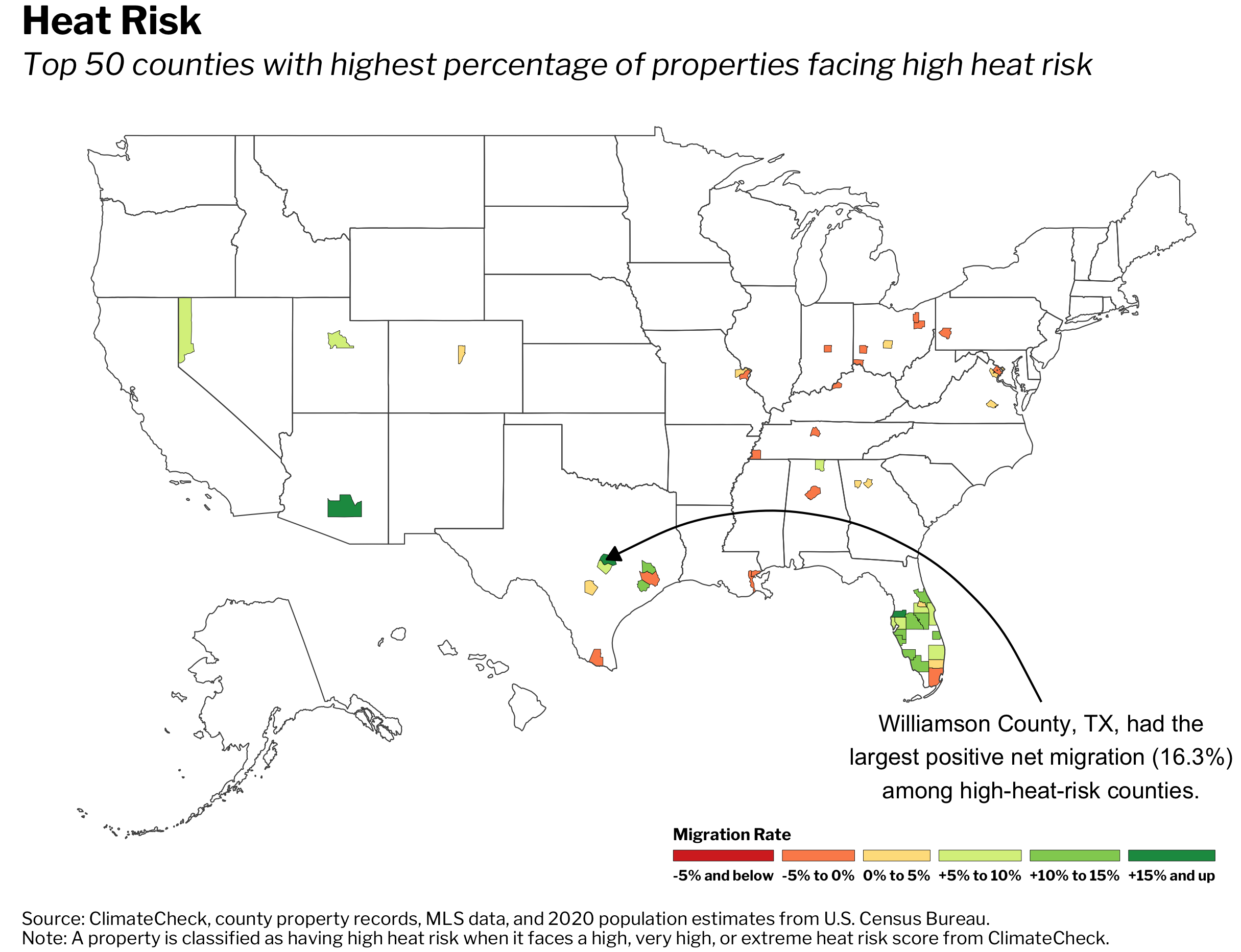
Climate Migration: Counties With High Heat Risk
Heat risk is based on the number of extremely hot days expected in the future. Of the 50 U.S. counties with the highest share of properties facing high heat risk, 37 are in the South, with one-third (17) in Florida alone. More than half (33) of those 50 counties experienced positive net migration over the last five years.
Williamson County, TX—part of the Austin metro area where every home faces high heat risk—saw its population grow 16.3% due to positive net migration from 2016 through 2020. That’s the highest growth rate of the 50 counties Redfin analyzed. It was followed by Pinal County, AZ (just south of Phoenix), which had a positive net migration rate of 15.5%. Rounding out the top five were three Florida counties: Pasco County (15.4%), Osceola County (14.6%) and Manatee County (13.5%).
Migration to places with high heat risk has accelerated over time: All but one of the top five counties saw their net migration rates increase from the prior five-year period—2011 through 2015. The largest jump was in Pinal County, where the rate jumped from 4.1% (2011 through 2015) to 15.5% (2016 through 2020).
Top Five High-Heat-Risk Counties By 2016-2020 Net Migration Rate
| Net Migration Rate, 2016-2020 | Net Migration Rate, 2011-2015 | Number of Homes With High Heat Risk | Dollar Value of Homes With High Heat Risk | Share of Homes With High Heat Risk | Median Sale Price (2020) | |
| Williamson County, TX | 16.3% | 12.9% | 200,250 | $88,880,025,301 | 100% | $304,295 |
| Pinal County, AZ | 15.5% | 4.1% | 139,891 | $47,279,687,220 | 100% | $258,158 |
| Pasco County, FL | 15.4% | 7% | 194,001 | $52,656,679,700 | 100% | $238,964 |
| Osceola County, FL | 14.6% | 14.6% | 134,856 | $38,981,773,642 | 100% | $260,583 |
| Manatee County, FL | 13.5% | 11.5% | 164,900 | $65,584,816,014 | 100% | $304,175 |
All five of the counties in the table above are part of metropolitan areas that have been surging in popularity among out-of-towners. The Phoenix metro area was the number-one U.S. migration destination in the second quarter of 2021, with 37.5% of Redfin.com home searches coming from outside the metro. Austin was close behind, along with the Tampa and Orlando metros, which include the Florida counties in the table above. Interest in warm, relatively affordable areas—especially in suburbs of large cities—has accelerated during the pandemic.
Williamson County, which includes the northern tip of Austin, has exploded in recent years as major companies have set up shop in the area and developers have built more apartments, entertainment and shopping centers, according to local Redfin real estate agent Barb Cooper. Dell Technologies Inc. is headquartered in Williamson County, and Apple Inc. plans to have 5,000 employees in its new $1 billion Williamson County campus next year. There are also several universities and a new hospital complex located in the area.
“Williamson County includes many of the Austin suburbs that have seen exponential growth as more folks have moved in from outside the area—especially California—in search of more space and relative affordability,” Cooper said. “It used to be really hard to sell a custom home with a pool on an acre of land here, and now those homes are selling like hotcakes because so many people are working remotely and want room for home offices. And if they need to go into their actual office, it’s an easy commute to the tech hub in Northwest Austin.”
Cooper continued: “Homebuyers in Williamson County sometimes ask about utility costs—especially after the major power outage caused by the snowstorm this winter—but they don’t seem too concerned about the heat,” Cooper said. “Part of that may be because you don’t know what you don’t know; if you come from an area that hasn’t experienced significant heat or drought, you might not be aware of the implications for homeowners. For example, when it gets hot and dry here, local authorities often put restrictions on how much water homeowners can use, shut down car washes and only let people water their yards on certain days.”
The weather in Williamson County is actually a lure for some house hunters coming from chillier states or from Northern Texas, which has a more humid climate, Cooper added.
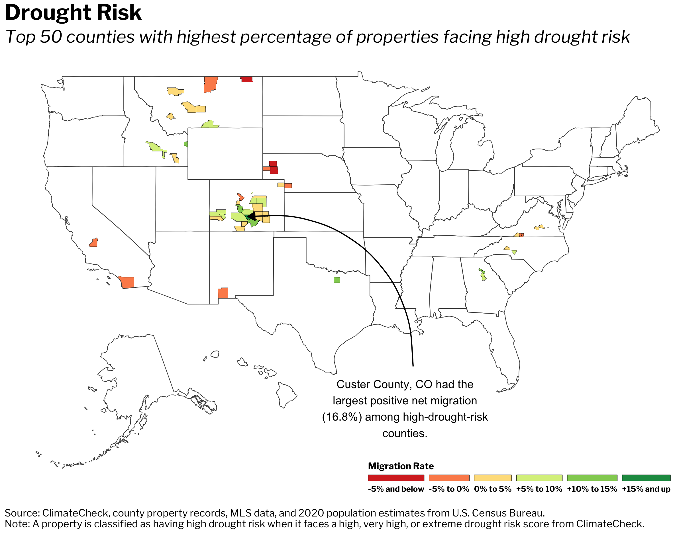
Climate Migration: Counties With High Drought Risk
Drought risk is based on expected water-supply stress, which measures how much of the available water in an area is used by humans. Of the 50 counties with the highest share of properties facing high drought risk, 34 are in the West, with 21 in Colorado alone. More than half (38) of those 50 counties experienced positive net migration over the past five years.
Custer County, CO—a rural area south of Denver where nearly every home faces high heat risk—experienced 16.8% population growth due to positive net migration from 2016 through 2020. That’s the highest growth rate of the 50 counties Redfin analyzed. It was followed by Denton County, TX (north of Dallas), which had a positive net migration rate of 13%. Next came Oconee County, GA (12.6%), Huerfano County, CO (11.9%) and Chaffee County, CO (11.5%). All five counties saw their net migration rates increase from the prior five-year period.
Top Five High-Drought-Risk Counties By 2016-2020 Net Migration Rate
| Net Migration Rate, 2016-2020 | Net Migration Rate, 2011-2015 | Number of Homes With High Drought Risk | Dollar Value of Homes With High Drought Risk | Share of Homes With High Drought Risk | Median Sale Price (2020) | |
| Custer County, CO | 16.8% | 4.8% | 3,869 | N/A* | 100% | N/A† |
| Denton County, TX | 13% | 11% | 259,506 | $107,708,019,969 | 99.9% | $327,620 |
| Oconee County, GA | 12.6% | 6.8% | 13,197 | $5,705,583,741 | 100% | N/A† |
| Huerfano County, CO | 11.9% | -0.2% | 3,597 | N/A* | 100% | N/A† |
| Chaffee County, CO | 11.5% | 5.4% | 7,033 | $3,692,484,404 | 100% | $425,888 |
*Redfin Estimates were not available for given county
†MLS sale-price data was not available for given county
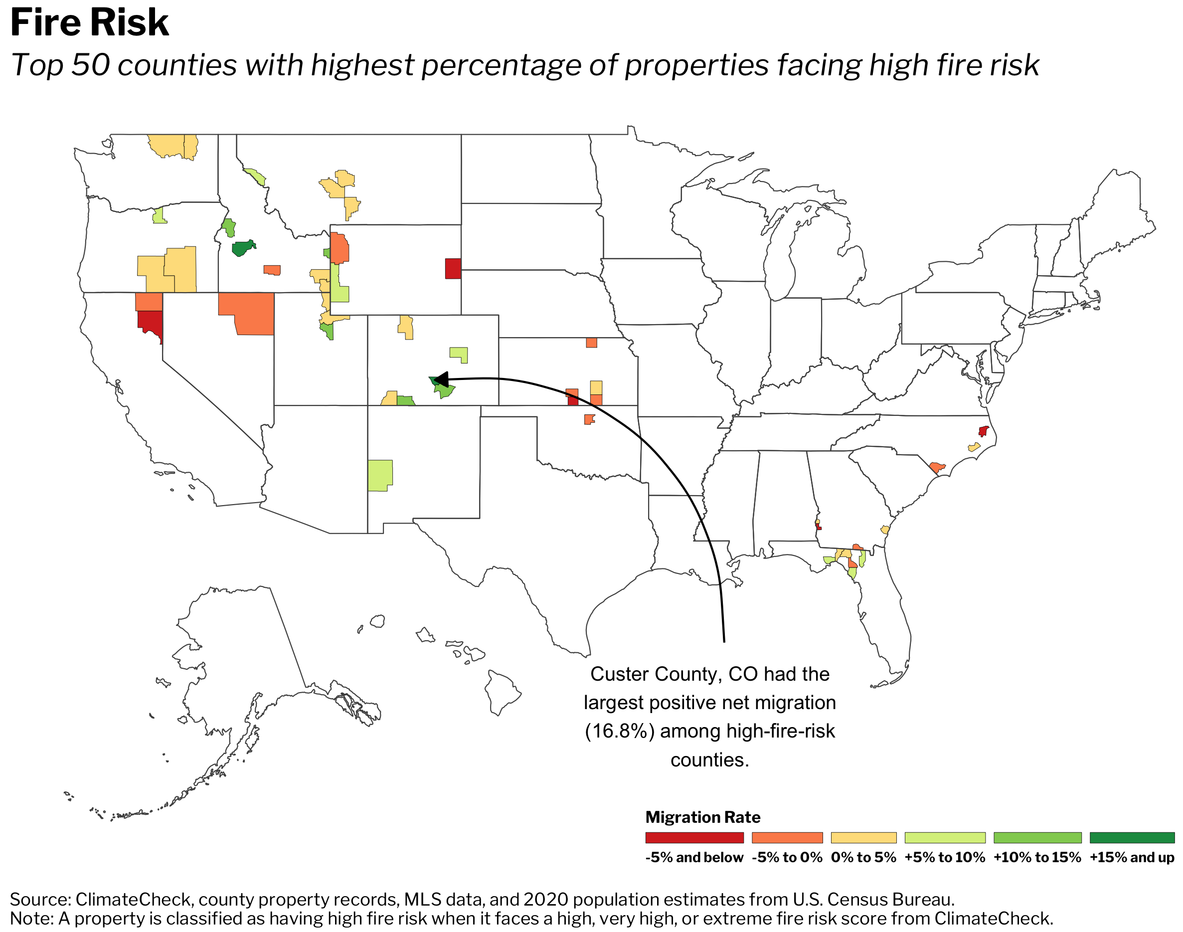
Climate Migration: Counties With High Fire Risk
Fire risk is based on projections of the average share of the area surrounding a home that will burn annually. Of the 50 counties with the highest share of properties facing high fire risk, 31 are in the West. More than half (34) of those 50 counties experienced positive net migration over the past five years.
Custer County, CO experienced 16.8% population growth due to positive net migration from 2016 through 2020—the highest positive net migration rate of the 50 counties Redfin analyzed. It was followed by Boise County, ID, which had a positive net migration rate of 15.2%, and Wasatch County, UT, which is just outside of Salt Lake City and had a positive net migration rate of 14.7%. Rounding out the top five were Adams County, ID (14.2%) and Archuleta County, CO (12.8%). Four of the five counties saw their net migration rates increase from the prior five-year period.
Top Five High-Fire-Risk Counties By 2016-2020 Net Migration Rate
| Net Migration Rate, 2016-2020 | Net Migration Rate, 2011-2015 | Number of Homes With High Fire Risk | Dollar Value of Homes With High Fire Risk | Share of Homes With High Fire Risk | Median Sale Price (2020) | |
| Custer County, CO | 16.8% | 4.8% | 3,702 | N/A* | 95.7% | N/A† |
| Boise County, ID | 15.2% | 0.1% | 917 | $324,381,089 | 98.8% | $355,326 |
| Wasatch County, UT | 14.7% | 15% | 20,376 | $16,796,475,421 | 96% | $648,257 |
| Adams County, ID | 14.2% | -0.9% | 1,193 | $449,525,824 | 96.1% | $343,790 |
| Archuleta County, CO | 12.8% | 1.7% | 7,343 | N/A* | 98.5% | N/A† |
*Redfin Estimates were not available for given county
†MLS sale-price data was not available for given county
Boise County and Wasatch County are rural, mountainous regions outside of Boise and Salt Lake City, respectively. The Boise and Salt Lake City areas have become increasingly popular with out-of-towners in recent years—a trend that accelerated during the pandemic as house hunters sought relative affordability, space and access to the outdoors. More than a third (35.7%) of Redfin.com home searches in the Salt Lake City metropolitan area came from outside of the metro in the first quarter, up from 26.8% a year earlier. Utah, which has a larger share of homes facing high fire risk than any other Western state analyzed by Redfin, has seen its population grow faster than any other state.
“Salt Lake City proper is relatively insulated from fires because it’s located in a valley, but much of the mountainous area surrounding it—especially the Wasatch Range to the east and the north—is covered with dry vegetation that’s prone to burning. A lot of people live in these mountains or right up against them,” said Ryan Aycock, Redfin’s market manager in Salt Lake City. “Many of the homes in Wasatch Range are farm communities or cabins, but there are also luxury homes at risk in Park City, a resort town that’s been very popular during the pandemic. Park City is a mix of vacation and primary homes, but we’ve recently seen an increase of families coming in from Seattle, California and New York to buy primary homes because they can work from anywhere and want to be near great skiing and hiking.”
Aycock continued: “For the most part, the buyers and sellers don’t seem too worried about fires. They’re more concerned about droughts and water shortages,” Aycock said. “We’ve had a lot of near misses in Utah—there will be a fire warning, and then the fire isn’t as bad as people feared. It’s a bit of a boy-who-cried-wolf situation. A lot of folks could be caught flat-footed if a major fire does hit their community. Anyone who’s considering moving to the area should read the local fire planning and evacuation guides and create their own plan of action so they’re prepared when fires hit.”
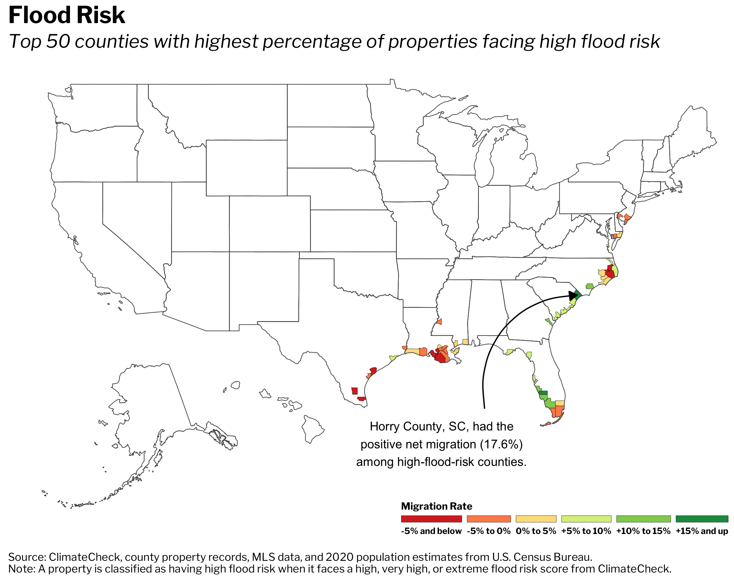
Climate Migration: Counties With High Flood Risk
Flood risk is based on the likelihood of significant flooding between 2020 and 2050. Of the 50 counties with the highest share of properties facing high flood risk, a majority (47) are in the South—specifically in Florida, Louisiana and North Carolina. Just over half (28) of those 50 counties experienced positive net migration from 2016 through 2020.
Horry County, SC, which includes Myrtle Beach, experienced 17.6% population growth from 2016 through 2020 due to positive net migration. That’s the highest increase among the 50 counties Redfin analyzed. It was followed by Charlotte County, FL at 16.8%, Sarasota County, FL (includes Sarasota) at 12.7%, Lee County, FL at 12.7% and Bryan County, GA (just south of Savannah) at 12.2%. All five counties saw their positive net migration rates increase from the prior five-year period.
Top Five High-Flood-Risk Counties By 2016-2020 Net Migration Rate
| Net Migration Rate, 2016-2020 | Net Migration Rate, 2011-2015 | Number of Homes With High Flood Risk | Dollar Value of Homes With High Flood Risk | Share of Homes With High Flood Risk | Median Sale Price (2020) | |
| Horry County, SC | 17.6% | 12.9% | 125,093 | $32,428,236,668 | 54.9% | $219,525 |
| Charlotte County, FL | 16.8% | 11.5% | 81,573 | $26,672,852,475 | 84.3% | $240,742 |
| Sarasota County, FL | 12.7% | 9.2% | 119,551 | $69,558,340,052 | 53.9% | $296,781 |
| Lee County, FL | 12.7% | 11.8% | 295,476 | $121,983,528,367 | 80.3% | $257,717 |
| Bryan County, GA | 12.2% | 9.6% | 7,994 | N/A* | 58.0% | $276,720 |
*Redfin Estimates were not available for given county
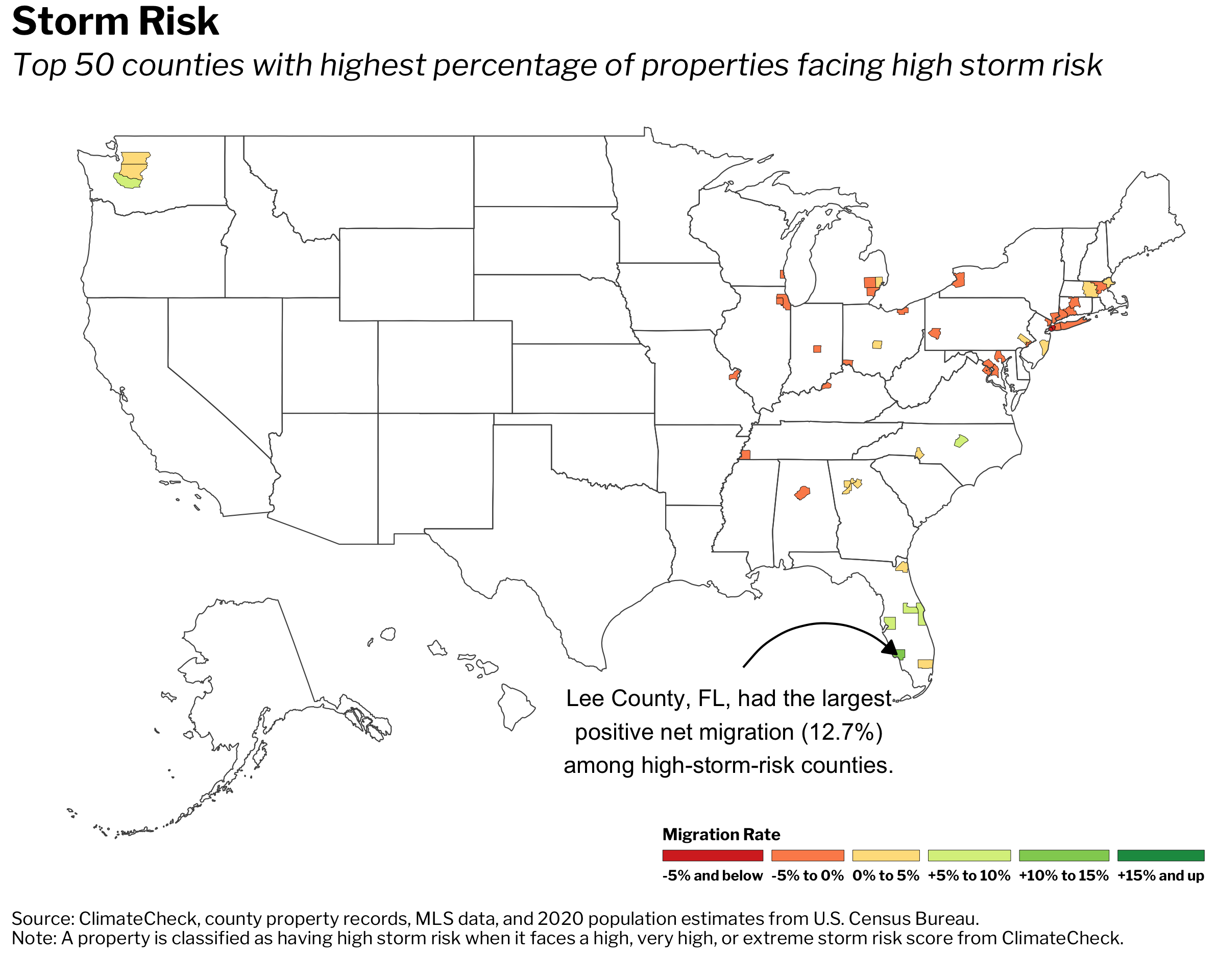
Climate Migration: Counties With High Storm Risk
Storm risk is based on projections of the number of extremely wet or snowy events and the amount of rain or snow that will fall during storms. Of the 50 counties with the highest share of properties facing high storm risk, a majority are in the Northeast or Southeast. While 20 of those 50 counties experienced positive net migration over the past five years, the remainder experienced negative net migration.
Lee County, FL, which includes the cities of Cape Coral and Fort Myers, experienced 12.7% population growth from 2016 through 2020 due to positive net migration. That’s the highest increase among the 50 counties Redfin analyzed. It was followed by Brevard County, FL (includes Cape Canaveral), which had a positive net migration rate of 9.2%. Next came Hillsborough County, FL (includes Tampa) at 7.2%, Wake County, NC (includes Raleigh) at 7% and Pierce County, WA (includes Tacoma) at 5.4%. Three of the five counties saw their positive net migration rates increase from the prior five-year period.
Top Five High-Storm-Risk Counties By 2016-2020 Net Migration Rate
| Net Migration Rate, 2016-2020 | Net Migration Rate, 2011-2015 | Number of Homes With High Storm Risk | Dollar Value of Homes With High Storm Risk | Share of Homes With High Storm Risk | Median Sale Price (2020) | |
| Lee County, FL | 12.7% | 11.8% | 368,149 | $140,838,419,240 | 100% | $257,717 |
| Brevard County, FL | 9.2% | 5.2% | 246,483 | $78,178,439,832 | 100% | $251,809 |
| Hillsborough County, FL | 7.2% | 7.3% | 446,769 | $151,507,295,021 | 100% | $262,507 |
| Wake County, NC | 7% | 7.9% | 369,636 | $152,086,486,189 | 100% | $336,847 |
| Pierce County, WA | 5.4% | 2.8% | 266,983 | $141,600,703,809 | 100% | $415,563 |
Cape Coral, Tampa and Orlando—all of which are prone to hurricanes—were among the 10 most popular migration destinations in the second quarter, and Raleigh has made the list in years past. Meanwhile, Tacoma was named the hottest housing market by Redfin in 2019, fueled by an influx of residents who had been priced out of Seattle.
Of the 50 counties with the greatest share of homes facing high storm risk, Kings County, NY (Brooklyn), Queens County, NY (Queens) and Cook County, IL (Chicago) experienced the greatest population declines due to negative net migration, falling a respective 7%, 6.4% and 4.7% from 2016 through 2020. New York and Illinois were leading the country in population declines even before the pandemic, which exacerbated an exodus from major job centers.
Methodology
Climate-risk data for drought, fire, flood, heat, and storm comes from ClimateCheck, which assigns six different climate-risk categories to properties across the U.S.—very low, low, moderate, high, very high and extreme. For this report, a “high-risk” property is one that falls into the high, very high, or extreme category for a given climate risk. The climate-risk data in this report is as of March 31, 2021.
For each environmental disaster—drought, fire, flood, heat, and storm—we identified the 50 U.S. counties with the largest share of homes facing high risk. Counties must have had at least 500 homes as of Aug. 2, 2021 to be included. We then calculated net migration from 2016 through 2020 and 2011 through 2015. Net migration (the difference between the number of international and domestic people moving into an area and the number moving out) data comes from the U.S. Census Bureau’s Vintage 2020 population estimates. We calculated five-year cumulative net migration by adding each yearly estimate for those years. The value of homes at risk is the sum of the Redfin Estimates of the homes’ market values as of Aug. 2, 2021. We only show dollar values of homes facing high climate risk for those counties covered by Redfin Estimates. Median sale prices for 2020 were calculated by averaging monthly median sale prices during that year.
No comments:
Post a Comment